Enable Location

We need your location to show you interesting places around you

Discover nearby places

Find interesting locations and hidden gems around you

Precise directions

Get accurate directions and distances to places

Your location is never shared with other users. It's only used when you tap the location button.

Otero County

Log in to your account

Start exploring — it's free

Trusted by 62,179 travelers worldwide

Continue with Google
Continue with Apple
or

We will send you a code to connect

By continuing, you accept our Terms and Conditions and our Privacy Policy

Check your inbox

We've sent a pincode in your inbox. Please enter the code below.

Otero County, Administrative division in Colorado, United States.

Otero County is an administrative division in Colorado that operates under a Board of County Commissioners responsible for managing local governance and community affairs. The board oversees various county operations and meets regularly to address matters affecting residents throughout the region.

The region was established as a county with a governance structure featuring elected commissioners to handle local administration. Over time, the administrative system has developed to manage the evolving needs of communities across the area.

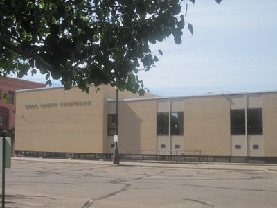
Public participation remains central to county operations, with commissioners conducting regular meetings in the Bauserman Conference Room of the Otero County Courthouse.

The Board meets at scheduled times, making it easy to learn about current matters being handled. Visitors can contact local offices to find information about ongoing programs and services available to the public.

The county maintains three distinct commissioner districts, each represented by an elected official who serves specific geographic areas within the jurisdiction.

The community of curious travelers

AroundUs brings together thousands of curated places, local tips, and hidden gems, enriched daily by 60,000 contributors worldwide.

Start exploring
GPS coordinates
37.88721,-103.74153
Latest update
December 7, 2025 20:21
Around this place
Fort Lyon
United States of America

Fort Lyon

57.3 km
Piñon Canyon Maneuver Site
United States of America

Piñon Canyon Maneuver Site

54.8 km
John Martin Reservoir
United States of America

John Martin Reservoir

71.9 km
Purgatoire River track site
United States of America

Purgatoire River track site

32.6 km
Pueblo Weisbrod Aircraft Museum
United States of America

Pueblo Weisbrod Aircraft Museum

79.4 km
John Martin Reservoir State Park
United States of America

John Martin Reservoir State Park

74.1 km
Koshare Indian Museum
United States of America

Koshare Indian Museum

19.7 km
Bent County High School
United States of America

Bent County High School

48.9 km
Minnequa Steel Works Office Building and Dispensary, Colorado Fuel and Iron Company
United States of America

Minnequa Steel Works Office Building and Dispensary, Colorado Fuel and Iron Company

85.8 km
Steelworks Museum of Industry and Culture
United States of America

Steelworks Museum of Industry and Culture

85.7 km
Pueblo Levee Mural Project
United States of America

Pueblo Levee Mural Project

86.4 km
Quaker Flour Mill
United States of America

Quaker Flour Mill

86.7 km
St. Charles Bridge
United States of America

St. Charles Bridge

78.7 km
Crowley School
United States of America

Crowley School

35.6 km
Veterans' Bridge
United States of America

Veterans' Bridge

86.8 km
Dr. Frank Finney House
United States of America

Dr. Frank Finney House

20.1 km
Butler House
United States of America

Butler House

64.1 km
Avondale Bridge
United States of America

Avondale Bridge

66.3 km
Hotel Holly–Haswell Hotel
United States of America

Hotel Holly–Haswell Hotel

80.8 km
Art Building
United States of America

Art Building

19.2 km
Carnegie Public Library
United States of America

Carnegie Public Library

18.2 km
Huerfano Bridge
United States of America

Huerfano Bridge

59.1 km
Wilson A. Hart House
United States of America

Wilson A. Hart House

20.4 km
Fox Theater
United States of America

Fox Theater

20.6 km
Grand Theater
United States of America

Grand Theater

18.3 km
Mesa Drive-In
United States of America

Mesa Drive-In

82.3 km
Fay's Crossing Bridge
United States of America

Fay's Crossing Bridge

86.6 km
Santa Fe Avenue Bridge
United States of America

Santa Fe Avenue Bridge

86.1 km
Show the full map
« Otero County - Administrative division in Colorado, United States » is provided by Around Us (aroundus.com). Images and texts are derived from Wikimedia project under a Creative Commons license. You are allowed to copy, distribute, and modify copies of this page, under the conditions set by the license, as long as this note is clearly visible.

Discover hidden gems everywhere you go!

From secret cafés to breathtaking viewpoints, skip the crowded tourist spots and find places that match your style. Our app makes it easy with voice search, smart filtering, route optimization, and insider tips from travelers worldwide. Download now for the complete mobile experience.

Around Us App Screenshot

A unique approach to discovering new places

Le Figaro

All the places worth exploring

France Info

A tailor-made excursion in just a few clicks

20 Minutes

Around Us
Travel Guide & Maps
Download

Send to your phone

QR Code
1

Open the camera app on your mobile.

2

Point at the QR code with your camera. A notification will appear.

3

Tap the notification to open the link.