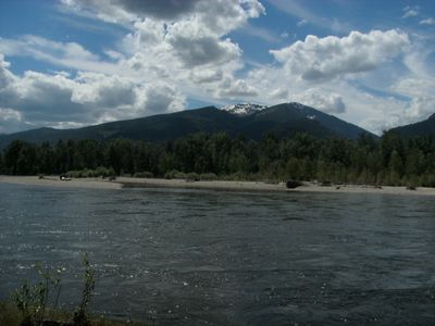
Bitterroot River, River system in Missoula and Ravalli Counties, Montana.
The Bitterroot River is a river system in western Montana that flows northward for about 84 miles from its source to its mouth. It begins where two main branches meet near the town of Conner and continues through valleys and open country before joining the Clark Fork River.
Indigenous Salish peoples originally called this waterway Spet-lum, while French fur traders later renamed it racine amère based on the bitterroot plant. The shift in names shows how the river was understood and used by different groups who came to this region at different times.
The river takes its name from the bitterroot plant, which indigenous peoples gathered along its banks for food over countless generations. This connection between the waterway and the plants growing nearby shaped how the place was understood and used by those who lived there.
Several towns along the river provide entry points for those who want to fish, with Hamilton, Stevensville, and Darby offering the main access routes. Local conditions change seasonally, so it helps to check water levels and weather before planning your time there.
The waterway supports populations of native westslope cutthroat trout and bull trout that thrive in its waters. These fish species draw people who want to experience the river's natural character and wildlife.
The community of curious travelers
AroundUs brings together thousands of curated places, local tips, and hidden gems, enriched daily by 60,000 contributors worldwide.