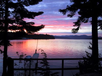
Priest Lake, Lake in northern Idaho, United States.
The lake extends across 31 square kilometers with a maximum depth of 39 feet (12 meters), positioned at an elevation of 2,441 feet (744 meters) in the northern part of the Idaho Panhandle, surrounded by forested areas and mountains.
Pierre-Jean De Smet initially named the body of water De Boey Lake to honor his Belgian patron, while Captain John Mullan introduced its current name in 1865 after mapping the area during his surveying expeditions.
The name Kaniksu Lake means black robes in local indigenous language, referring to the area's importance for various tribes who maintained fishing grounds and seasonal camps here before European settlers arrived in the region.
The water connects with the Priest River system and offers year-round opportunities for fishing, boating, and water recreation, with several public access points along the shoreline available for visitors throughout different seasons.
During De Smet's first documentation of the water body in the 19th century, he recorded large populations of swans, ducks, and wild geese inhabiting the area, demonstrating the richness of wetland habitats in this remote mountain region.
Location: Idaho
GPS coordinates: 48.56667,-116.86667
Latest update: December 22, 2025 12:04
Idaho's remote locations offer access to diverse landscapes ranging from alpine lakes nestled in mountain ranges to volcanic formations and high desert terrain. The state contains geological features formed over thousands of years, including lava tubes that preserve ice year-round, sand dunes rising...
Priest Lake State Park
5.8 kmLamb Creek School
7 kmKaniksu Marsh Research Natural Area
14.6 kmGalena Point
20.3 kmMill Creek Point
21.6 kmUleda Point
24.5 kmMcArthur Lake
31.2 kmGoose Creek Point
22.3 kmPriest River Experimental Forest
23.8 kmChipmunk Rapids
16.3 kmLeClerc Wildlife Area
31.2 kmHill's Resort
5.2 kmScenic viewpoint
26.5 kmCavanughs
5.7 kmPriest Lake Golf Course
6.8 kmThe Cantina and Beach Bar
4.6 kmStatue, Work of art
28.5 kmUleda Ridge Viewpoint
27.5 kmScenic viewpoint
16 kmScenic viewpoint
26.5 kmIndian Rock
2.8 kmScenic viewpoint
20.7 kmScenic viewpoint
10.7 kmMission Falls
16.8 kmHunt Falls
3.4 kmLaSota Falls
26.8 kmLower Granite Falls
26.5 kmUpper Granite Falls
26.7 kmVisited this place? Tap the stars to rate it and share your experience / photos with the community! Try now! You can cancel it anytime.
Discover hidden gems everywhere you go!
From secret cafés to breathtaking viewpoints, skip the crowded tourist spots and find places that match your style. Our app makes it easy with voice search, smart filtering, route optimization, and insider tips from travelers worldwide. Download now for the complete mobile experience.
A unique approach to discovering new places❞
— Le Figaro
All the places worth exploring❞
— France Info
A tailor-made excursion in just a few clicks❞
— 20 Minutes