Enable Location

We need your location to show you interesting places around you

Discover nearby places

Find interesting locations and hidden gems around you

Precise directions

Get accurate directions and distances to places

Your location is never shared with other users. It's only used when you tap the location button.

Log in to your account

Start exploring — it's free

Trusted by 67,925 travelers worldwide

Continue with Google
Continue with Apple
or

We will send you a code to connect

By continuing, you accept our Terms and Conditions and our Privacy Policy

Check your inbox

We've sent a pincode in your inbox. Please enter the code below.

Confederate Gulch and Diamond City
Discussion Reviews Photo
8.9k Popularity

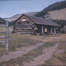
Confederate Gulch and Diamond City, Mining ghost town in Broadwater County, Montana.

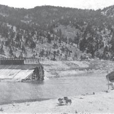
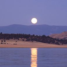
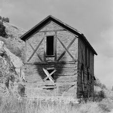
Confederate Gulch and Diamond City refer to an abandoned gold rush settlement tucked into a narrow valley of the Big Belt Mountains in Montana, where a stream runs westward toward Canyon Ferry Lake. A handful of timber remnants and old mining spoils still dot the site where the town once stood.

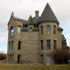
Gold was found here in 1865, and within months a proper town called Diamond City took shape, drawing miners from across the region. The rush faded almost as fast as it began, and the town was largely empty within a few years.

The name Confederate Gulch comes from Civil War veterans who arrived here after the war ended and found gold in the stream beds. Their presence shaped the identity of this remote valley in a way that its name still echoes today.

The site is reached by unpaved roads that can be rough after rain or in winter, so a high-clearance vehicle is a good idea. Once there, the ground is uneven and loose in places, so solid footwear makes the walk much more comfortable.

In the richest stretches of the stream, individual miners reportedly washed out several pounds of gold in a single day, making this one of the most productive placers ever worked in the region. That level of output drew enormous crowds but also exhausted the deposits faster than anyone expected.

The community of curious travelers

AroundUs brings together thousands of curated places, local tips, and hidden gems, enriched daily by 60,000 contributors worldwide.

Start exploring
Location
GPS coordinates
46.59720,-111.42400
Latest update
March 3, 2026 10:11
Around this place
Cathedral of Saint Helena
United States of America

Cathedral of Saint Helena

46.6 km
Hauser Dam
United States of America

Hauser Dam

39.9 km
Canyon Ferry Dam
United States of America

Canyon Ferry Dam

23.9 km
Confederate Memorial Fountain
United States of America

Confederate Memorial Fountain

47.1 km
Temple Emanu-El
United States of America

Temple Emanu-El

46.5 km
Helena Montana Temple
United States of America

Helena Montana Temple

45.6 km
Helena Civic Center
United States of America

Helena Civic Center

47.1 km
Helena Historic District
United States of America

Helena Historic District

47.3 km
Black Sandy State Park
United States of America

Black Sandy State Park

39 km
Byron R. Sherman House
United States of America

Byron R. Sherman House

40.4 km
Kluge House
United States of America

Kluge House

38.7 km
St. Joseph's Catholic Mission Church
United States of America

St. Joseph's Catholic Mission Church

21 km
W.C. Child Ranch
United States of America

W.C. Child Ranch

37.5 km
State Bank of Townsend
United States of America

State Bank of Townsend

31.9 km
Lewis and Clark County Hospital Historic District
United States of America

Lewis and Clark County Hospital Historic District

46.9 km
Eagle Guard Station
United States of America

Eagle Guard Station

37.7 km
Parberry Block East
United States of America

Parberry Block East

40.2 km
Porter Flats Apartments
United States of America

Porter Flats Apartments

46.7 km
Olsen House
United States of America

Olsen House

47.1 km
Morris Silverman House
United States of America

Morris Silverman House

46.5 km
T. H. Kleinschmidt House
United States of America

T. H. Kleinschmidt House

44.6 km
Great Northern Carousel
United States of America

Great Northern Carousel

46.9 km
Robert and Elizabeth Fisk House
United States of America

Robert and Elizabeth Fisk House

46.5 km
Young Women's Christian Association
United States of America

Young Women's Christian Association

47.4 km
Montana Veterans and Pioneers Memorial Building
United States of America

Montana Veterans and Pioneers Memorial Building

45.2 km
Wick-Seiler House
United States of America

Wick-Seiler House

46.2 km
St John's Lutheran Church (Helena)
United States of America

St John's Lutheran Church (Helena)

46.1 km
Former Montana Executive Mansion
United States of America

Former Montana Executive Mansion

46.7 km
Show the full map
Reviews
Share your experience

No review yet

Discussions
Start a discussion...

No discussion yet

« Confederate Gulch and Diamond City - Mining ghost town in Broadwater County, Montana » is provided by Around Us (aroundus.com). Images and texts are derived from Wikimedia project under a Creative Commons license. You are allowed to copy, distribute, and modify copies of this page, under the conditions set by the license, as long as this note is clearly visible.

Discover hidden gems everywhere you go!

From secret cafés to breathtaking viewpoints, skip the crowded tourist spots and find places that match your style. Our app makes it easy with voice search, smart filtering, route optimization, and insider tips from travelers worldwide. Download now for the complete mobile experience.

Around Us App Screenshot

A unique approach to discovering new places

Le Figaro

All the places worth exploring

France Info

A tailor-made excursion in just a few clicks

20 Minutes

Around Us
Travel Guide & Maps
Download

Send to your phone

QR Code
1

Open the camera app on your mobile.

2

Point at the QR code with your camera. A notification will appear.

3

Tap the notification to open the link.