Kitimat, Industrial district municipality in North Coast region, British Columbia, Canada
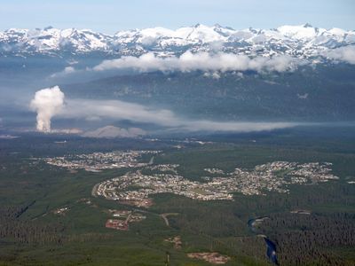
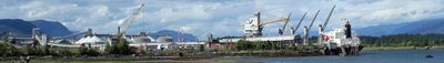
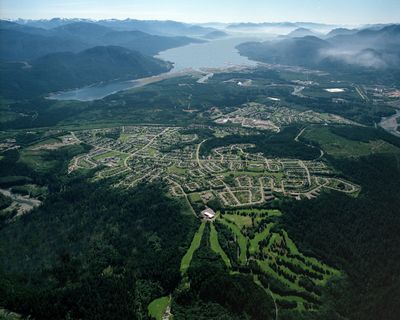
Kitimat is a district municipality in northwestern British Columbia that stretches along a fjord arm surrounded by mountains and forests. The settlement sits at low elevation and centers around a major aluminum smelting operation.
A former fishing village was transformed into an industrial center in the 1950s through a major hydroelectric and smelting project. This project brought workers and infrastructure to the region, permanently reshaping the local economy.
The population of 8,131 residents includes European, Indigenous, Southeast Asian, and South Asian communities, forming a multicultural industrial municipality.
The municipality is reachable by road via the northern Coastal Highway and has basic shopping and dining options in the town center. Visitors should note that the area is isolated and should plan supplies or reservations in advance.
A mountain dam generates electricity specifically for aluminum production, making this one of the most energy-intensive places in the region. This link between hydropower and metal processing is uncommon and shapes the character of the area.
Location: Regional District of Kitimat-Stikine
Elevation above the sea: 40 m
Shares border with: Skeena Country
Website: https://kitimat.ca
GPS coordinates: 54.05333,-128.65222
Latest update: December 14, 2025 19:31
Kitimat River Provincial Park
7.1 kmDala-Kildala Rivers Estuaries Provincial Park
26.2 km
Foch-Gilttoyees Provincial Park
37.4 kmWeewanie Hot Springs Provincial Park
40.7 kmNalbeelah Creek Wetlands Provincial Park
11.3 kmSue Channel Provincial Park
38.5 kmCoste Rocks Provincial Park
28.8 kmEagle Bay Provincial Park
28.3 kmJesse Falls
28 kmFoch-Gilttoyees Protected Area
39.7 kmJesse Falls Protected Area
27.7 kmWeewanie Hot Springs
40.8 kmNechako Theatre
1.3 kmFire Mountain Hiking Trail
10.9 kmJesse Falls
28 kmFire Mountain Hiking Trail
5.7 kmGiant Sitka Spruce
1.9 kmHospital Beach
7.4 kmSunset view
1.6 kmScenic viewpoint
3.2 kmFire Mountain Hiking Trail
4.7 kmMoore Creek Falls
6.2 kmWaterfall
30.1 kmWaterfall
30.1 kmWaterfall
30.4 kmWaterfall
30.9 kmJesse Falls
28 kmWaterfall
12 kmVisited this place? Tap the stars to rate it and share your experience / photos with the community! Try now! You can cancel it anytime.
Discover hidden gems everywhere you go!
From secret cafés to breathtaking viewpoints, skip the crowded tourist spots and find places that match your style. Our app makes it easy with voice search, smart filtering, route optimization, and insider tips from travelers worldwide. Download now for the complete mobile experience.
A unique approach to discovering new places❞
— Le Figaro
All the places worth exploring❞
— France Info
A tailor-made excursion in just a few clicks❞
— 20 Minutes