Paskapoo Formation, Geological formation in Alberta, Canada
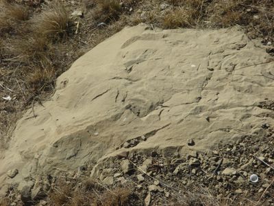
The Paskapoo Formation is a geological sequence in southwestern Alberta composed of layers of mudstone, siltstone, and sandstone reaching depths up to 600 meters (1,970 feet). These rock layers extend across a wide area and form the foundation of the region's soil and water systems.
Joseph Tyrrell first documented this formation in 1887 along the Blindman River at its confluence with the Red Deer River. His work established it as an important reference point for understanding the region's geological history.
The name Paskapoo comes from the Cree word 'paskapiw', meaning 'He is blind', which refers to the Blindman River in the area. This indigenous naming reflects how local peoples understood and described the landscape.
The formation holds freshwater aquifers that supply water for irrigation and drinking throughout southwestern Alberta. Access to this water source is essential for agriculture and settlements across the region.
In the early 1900s, sandstone from this formation was quarried for construction of fire-resistant buildings in Calgary. The material was valued for its ability to withstand fire and helped shape the city's growing architecture.
The community of curious travelers
AroundUs brings together thousands of curated places, local tips, and hidden gems, enriched daily by 60,000 contributors worldwide.