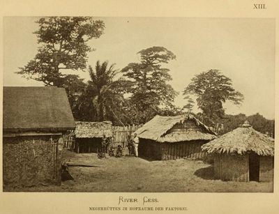
River Cess County, county of Liberia
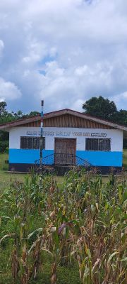
Rivercess is a county in southern Liberia that stretches from flat coastal plains to forested highlands. The region is shaped by the Cestos River and divided into eight districts with scattered villages, farmland, and an Atlantic Ocean coastline.
Rivercess was established as a separate county in 1984 to help local people govern themselves better. The region has developed gradually since then, with local leadership and community projects taking shape as residents returned home after the civil wars ended.
The name Rivercess comes from the Cestos River, which shapes the region and influences how people live here. Residents gather regularly at markets and community celebrations where traditional music, dance, and local food reflect their connection to the land and their shared heritage.
The region is mostly rural with simple roads and small communities where people travel mainly on foot or local paths. The best time to visit is during the dry season when roads are passable and you can reach markets and fishing villages more easily.
The flag of Rivercess features a rising sun over a green tree and a brown hut, symbols that represent hope, nature, and home for its residents. These images reflect the deep connection between the local people and their land and tell the story of who they are.
Location: Liberia
Inception: December 13, 1985
Capital city: River Cess
Reference: RI
Address: Rivercess, Liberia
GPS coordinates: 6.00000,-9.33333
Latest update: December 6, 2025 20:43
Liberia offers a range of places where history, nature, and culture come together. The country has a unique heritage as a settlement for formerly enslaved people who gained their freedom, which is reflected in its towns and landmarks. The landscape spans from tropical forests and waterfalls to coastal areas and wildlife reserves. In Monrovia, the capital, visitors can explore colonial architecture, museums, and beaches. The interior draws people with national parks like Sapo and Gola Forest, where rare animal species live. The coastal regions offer small villages, beaches, and chances to learn about local ways of life. This collection includes natural sites like Kpatawee Waterfalls and Blue Lake, as well as cultural places such as the National Museum and traditional markets. Each location tells a story about Liberia's past and natural variety.
Sapo National Park
104.4 km
Gibi National Forest
65.1 km
Borlola River Bridge
115.8 km
Sapo National Park (parke)
115.5 km
Krann-Bassa National Forest
53.9 km
Kpatawee Waterfall
129.5 km
Mont Nimba
120.1 km
Marshall Wetlands
114.8 km
Wulki Farm
143.3 km
Libassa Wildlife Sanctuary
128.8 km
Sam Arts Production Center
113.6 km
Zwedru Stadium View Point
132.7 km
Samuel Doe's House
133 km
Millennium Sport Center
111.7 km
Wilco Android
75.7 km
Bong Photo Star
112.2 km
Sunset Beach
79.4 km
Sunset Beach
78.1 km
Sapo National Park Headquarters
92 km
Kpatawe waterfall
129.5 km
Memorial
113 km
Ruins
68.6 km
Seah Land 1
123.9 km
Seah Land 1b
123.9 km
Waterfall
97.6 km
Waterfall
58.6 km
Waterfall
59.2 km
Waterfall
60.1 kmReviews
Visited this place? Tap the stars to rate it and share your experience / photos with the community! Try now! You can cancel it anytime.
Discover hidden gems everywhere you go!
From secret cafés to breathtaking viewpoints, skip the crowded tourist spots and find places that match your style. Our app makes it easy with voice search, smart filtering, route optimization, and insider tips from travelers worldwide. Download now for the complete mobile experience.
A unique approach to discovering new places❞
— Le Figaro
All the places worth exploring❞
— France Info
A tailor-made excursion in just a few clicks❞
— 20 Minutes