Säuling, Alpine peak between Schwangau, Germany and Pflach, Austria
Säuling is an Alpine peak located on the border between Germany and Austria with a distinctive pyramid shape. The mountain rises to around 2000 meters and forms a prominent landmark in the Ammergau Alps landscape.
The mountain served as a natural boundary between regions for centuries and appears in historical records as an important orientation marker. Its position along the dividing line influenced territorial development between Bavaria and Tyrol.
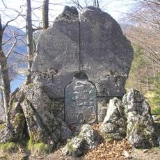
Local legend makes the summit plateau a witches' dance floor, and another tale says the devil tore a rock from the Säuling and dropped it near Roßhaupten when the evening bells rang; the monolith there carries a stone cross. The name likely derives from Siulinc, meaning column, matching the mountain's massive form; historian Magnus Peresson instead links it to Latin caelum, sky. The 1774 Atlas Tyrolensis marks it as "Seiling B."
The easiest route runs via the Säulinghaus, a Naturfreunde hut begun in 1925 at 1693 m; the top section is a marked trail with climbing safeguards at a few points. The longer ascent from Hohenschwangau over the Wildsulzhütte and the northeast scree slope, with descent past the Säulinghaus and around the Pilgerschrofen, takes six to seven hours. Memorial crosses along the way mark where mostly young climbers in their twenties died.
The Säulinghaus below the summit, a Naturfreunde hut of the Augsburg section, was begun in 1925 at 1,693 m. The 1774 Atlas Tyrolensis already marked the mountain as "Seiling B." The historian Magnus Peresson derives the name from Latin caelum, "sky", rather than from Säule, column.
The community of curious travelers
AroundUs brings together thousands of curated places, local tips, and hidden gems, enriched daily by 93,472 contributors worldwide.