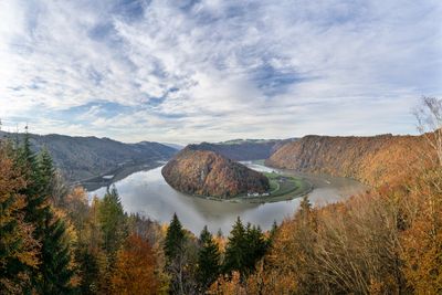
Schlögener Schlinge, River meander in Haibach ob der Donau, Austria
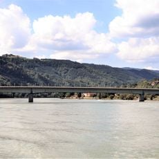
The Schlögener Schlinge is a river loop of the Danube located between Passau and Linz that has carved deeply through the granite highlands of Mühlviertel. The Danube winds here in an almost symmetrical arc, with the river channel spanning roughly 460 feet (140 meters) across and the viewpoint rising approximately 300 feet (90 to 100 meters) above the water.
The river carved this path through bedrock over roughly two million years while geological processes lifted the surrounding terrain. This deep erosion created the distinctive loop visible today and remains one of the Danube's most pronounced features in this region.
The name references the loop-like shape that defines this river formation and comes from the local dialect for a coil or knot. From above, the sharp bend appears almost like a horseshoe cut deep into the surrounding landscape.
The viewpoint is reachable from a parking area at Hotel Donauschlinge via a marked hiking trail that covers about 1.5 kilometers and climbs roughly 590 feet (180 meters). Sturdy footwear is recommended for the walk, which is suitable for visitors with reasonable fitness levels.
This formation ranks as Europe's largest forced meander, created when the river had to cut through hard bedrock instead of changing its course around it. This process, called a gorge or incised meander, reveals how water can overcome solid rock through persistence over vast time periods.
The community of curious travelers
AroundUs brings together thousands of curated places, local tips, and hidden gems, enriched daily by 60,000 contributors worldwide.