·

Enable Location

We need your location to show you interesting places around you

Discover nearby places

Find interesting locations and hidden gems around you

Precise directions

Get accurate directions and distances to places

Your location is never shared with other users. It's only used when you tap the location button.

Lac de la Vierre

Log in to your account

Start exploring — it's free

Trusted by 62,705 travelers worldwide

Continue with Google
Continue with Apple
or

We will send you a code to connect

By continuing, you accept our Terms and Conditions and our Privacy Policy

Check your inbox

We've sent a pincode in your inbox. Please enter the code below.

Lac de la Vierre

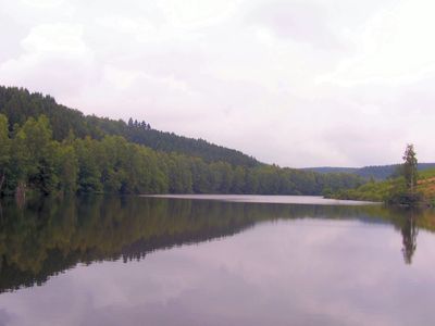
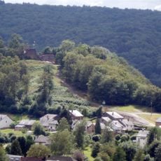
Lac de la Vierre, lac belge

Lac de la Vierre is an artificial reservoir near Ciney created by flooding about 25 hectares of land. Water reaches it through an underground pipeline that connects two rivers and passes beneath the Semois.

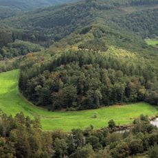
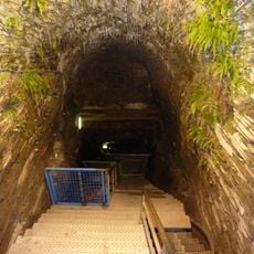
Construction of the reservoir began in 1963 and took two years, with crews blasting an 827 meter underground gallery. The project was designed to harness water power for electricity generation while creating a recreational space for the region.

The lake takes its name from the Vierre river, one of the waterways that feeds it. The shores have become a gathering place for fishers and walkers seeking quiet time in nature.

The lake is easily reached on foot with walking paths around the shoreline for leisurely strolls. Visitors should wear sturdy shoes and be prepared for variable weather, especially during early morning or evening hours.

Water is fed through an underground pipeline connecting two separate rivers while passing beneath a third, an ingenious engineering solution from the 1960s. This hidden infrastructure allows the lake to maintain consistent water levels even during dry periods.

The community of curious travelers

AroundUs brings together thousands of curated places, local tips, and hidden gems, enriched daily by 60,000 contributors worldwide.

Start exploring
Location
Elevation above the sea
395 m
GPS coordinates
49.73380,5.37759
Latest update
February 9, 2026 07:46
« Lac de la Vierre - lac belge » is provided by Around Us (aroundus.com). Images and texts are derived from Wikimedia project under a Creative Commons license. You are allowed to copy, distribute, and modify copies of this page, under the conditions set by the license, as long as this note is clearly visible.

Discover hidden gems everywhere you go!

From secret cafés to breathtaking viewpoints, skip the crowded tourist spots and find places that match your style. Our app makes it easy with voice search, smart filtering, route optimization, and insider tips from travelers worldwide. Download now for the complete mobile experience.

Around Us App Screenshot

A unique approach to discovering new places

Le Figaro

All the places worth exploring

France Info

A tailor-made excursion in just a few clicks

20 Minutes

Around Us
Travel Guide & Maps
Download

Send to your phone

QR Code
1

Open the camera app on your mobile.

2

Point at the QR code with your camera. A notification will appear.

3

Tap the notification to open the link.