Chest opened
+${chestReward.xp} XP
Explorer
NOUVEAU ×${chestReward.collectible.quantity}
tapez pour fermer
Chest locked

Open chests in the app

Around Us is built for your phone — chests unlock when you walk, explore and capture nearby places.

Enable Location

We need your location to show you interesting places around you

Discover nearby places

Find interesting locations and hidden gems around you

Precise directions

Get accurate directions and distances to places

Your location is never shared with other users. It's only used when you tap the location button.

Wawa

Log in to your account

Start exploring — it's free

Trusted by 72,888 travelers worldwide

Continue with Google
Continue with Apple
or

We will send you a code to connect

By continuing, you accept our Terms and Conditions and our Privacy Policy

Check your inbox

We've sent a pincode in your inbox. Please enter the code below.

Discussion Reviews 2 Photos
36.4k Popularity

Wawa, Administrative municipality in Algoma District, Canada

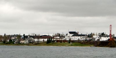
Wawa is a municipality in Algoma District, Ontario, located on the northeastern shore of Lake Superior and accessible via Highways 17 and 101. The town sits at an elevation of approximately 287 meters and functions as a key transportation hub for the region.

French explorers established the region in the 17th century, building Fort Michipicoten as an early European outpost for fur trading. This trading post marked the beginning of European presence in this remote area of northern Ontario.

The name Wawa derives from the Ojibwe language meaning wild goose, symbolized by a large steel monument at the town entrance. This landmark has become the visual identity of the place and reflects its connection to indigenous heritage.

The local information center provides travel guidance and recommendations from May through Canadian Thanksgiving weekend. The town is easily accessible via Highway 17 and works well as a stopping point when traveling through the region.

The area is known for its waterfalls, including Magpie Scenic High Falls which spans about 38 meters wide and drops roughly 22 meters. These natural formations draw visitors seeking to explore the wild landscapes surrounding the town.

The community of curious travelers

AroundUs brings together thousands of curated places, local tips, and hidden gems, enriched daily by 60,000 contributors worldwide.

Start exploring
Location
Inception
1899
Elevation above the sea
287 m
Shares border with
Unorganized North Algoma District
Website
GPS coordinates
47.99310,-84.77360
Latest update
December 17, 2025 10:55
Reviews
Share your experience

No review yet

Discussions
Start a discussion...

No discussion yet

« Wawa - Administrative municipality in Algoma District, Canada » is provided by Around Us (aroundus.com). Images and texts are derived from Wikimedia project under a Creative Commons license. You are allowed to copy, distribute, and modify copies of this page, under the conditions set by the license, as long as this note is clearly visible.

Discover hidden gems everywhere you go!

From secret cafés to breathtaking viewpoints, skip the crowded tourist spots and find places that match your style. Our app makes it easy with voice search, smart filtering, route optimization, and insider tips from travelers worldwide. Download now for the complete mobile experience.

Around Us App Screenshot

A unique approach to discovering new places

Le Figaro

All the places worth exploring

France Info

A tailor-made excursion in just a few clicks

20 Minutes

Around Us
Travel Guide & Maps
Download

Send to your phone

QR Code
1

Open the camera app on your mobile.

2

Point at the QR code with your camera. A notification will appear.

3

Tap the notification to open the link.