Île d'Orléans Bridge

Log in to your account

AroundUs is a community-driven map of interesting places, built by curious explorers like you. It grows with every review, story, and photo you share.
Connect to save your favorite spots, contribute locations, and create personalized routes.
Continue with Google
Continue with Apple
Continue with X
Continue with Facebook
Continue with email
By continuing, you accept our Terms and Conditions and our Privacy Policy
Create an account

Île d'Orléans Bridge

Add to collection
Map
Suggest a change
Share

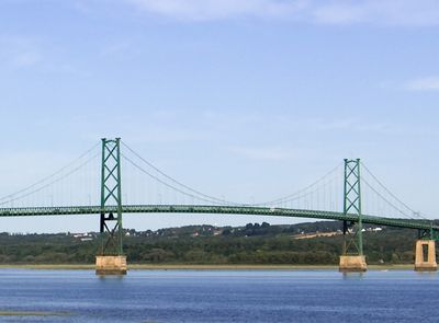
Île d'Orléans Bridge, Suspension bridge in Quebec City, Canada.

The Île d'Orléans Bridge is a steel suspension bridge that crosses the Saint Lawrence River and connects the north shore to an island community. Its main span stretches roughly 320 meters, while the towers rise approximately 66 meters above water level.

Construction began during the Great Depression in the 1930s as a job creation project that would connect the island to the mainland. The engineer Philip Louis Pratley designed this crossing, which finally gave year-round access to what had been a seasonally dependent community.

The bridge transformed how islanders lived by ending their dependence on seasonal ferry routes and winter ice roads. It connected a once-isolated community to the mainland in a way that changed daily routines permanently.

The bridge carries vehicle traffic on Quebec Route 368 and connects to the main highway on the north shore, making it the primary road access to the island. Walking or cycling across is not permitted, so a vehicle is necessary to use this crossing.

This structure holds the distinction of being the furthest downstream fixed crossing of the Saint Lawrence River in its region. Its location makes it a significant milestone in connecting communities that were previously dependent on water-based transportation methods.

Location: Beauport

Location: Saint-Pierre-de-l'Île-d'Orléans

Inception: 1934

Official opening: July 6, 1935

Height: 65.88 m

Made from material: steel

GPS coordinates: 46.88000,-71.13667

Latest update: December 6, 2025 17:41

Photos
Photo locations in Quebec: Montmorency Falls, Old Quebec, Château Frontenac

Quebec provides varied photographic settings across a province that combines French colonial heritage with extensive natural landscapes. In Quebec City, the stone buildings of Old Quebec, Fairmont Le Château Frontenac, and Montmorency Falls with its 83-meter drop form key subjects. The historic...

Reviews

Visited this place? Tap the stars to rate it and share your experience / photos with the community! Try now! You can cancel it anytime.

« Île d'Orléans Bridge - Suspension bridge in Quebec City, Canada » is provided by Around Us (aroundus.com). Images and texts are derived from Wikimedia project under a Creative Commons license. You are allowed to copy, distribute, and modify copies of this page, under the conditions set by the license, as long as this note is clearly visible.

Discover hidden gems everywhere you go!

From secret cafés to breathtaking viewpoints, skip the crowded tourist spots and find places that match your style. Our app makes it easy with voice search, smart filtering, route optimization, and insider tips from travelers worldwide. Download now for the complete mobile experience.

Around Us App Screenshot

A unique approach to discovering new places

Le Figaro

All the places worth exploring

France Info

A tailor-made excursion in just a few clicks

20 Minutes