Enable Location

We need your location to show you interesting places around you

Discover nearby places

Find interesting locations and hidden gems around you

Precise directions

Get accurate directions and distances to places

Your location is never shared with other users. It's only used when you tap the location button.

Temiskaming Shores

Log in to your account

Start exploring — it's free

Trusted by 62,814 travelers worldwide

Continue with Google
Continue with Apple
or

We will send you a code to connect

By continuing, you accept our Terms and Conditions and our Privacy Policy

Check your inbox

We've sent a pincode in your inbox. Please enter the code below.

Temiskaming Shores, Administrative hub in Timiskaming District, Ontario, Canada.

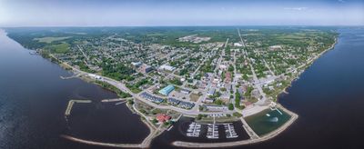
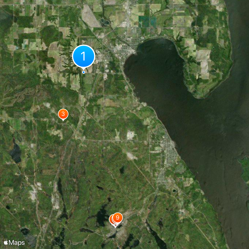
Temiskaming Shores is a town in Timiskaming District along the eastern shore of Lake Timiskaming, with New Liskeard as its main settlement. The surrounding landscape features rich soils ideal for farming, forming a distinctive region within Northern Ontario.

The settlement originated in 1891 when William Murray and Irvin Heard laid the groundwork for what would develop into a farming center. As the fertile soil proved valuable for agriculture, the town grew steadily through the early 20th century.

Farming traditions shape how people here use their land and gather together, visible in the seasonal markets and local events where residents connect over regional harvest and produce.

The town sits on Highway 11 with direct road access to Toronto, and regional bus services link it to neighboring areas. The downtown core is compact and easily navigable on foot for exploring local shops and attractions.

The fertile soils here result from a geological formation called the Clay Belt, which stands apart from the rocky terrain typical of Northern Ontario. This soil composition allowed farming to thrive where most other areas of the region cannot support agriculture.

The community of curious travelers

AroundUs brings together thousands of curated places, local tips, and hidden gems, enriched daily by 60,000 contributors worldwide.

Start exploring
Inception
January 1, 2004
Elevation above the sea
347.5 m
Shares border with
Kerns, Casey, Harley, Harris, Hudson, Cobalt, Coleman, Unorganized West Timiskaming District
GPS coordinates
47.49361,-79.71528
Latest update
December 19, 2025 23:37
« Temiskaming Shores - Administrative hub in Timiskaming District, Ontario, Canada » is provided by Around Us (aroundus.com). Images and texts are derived from Wikimedia project under a Creative Commons license. You are allowed to copy, distribute, and modify copies of this page, under the conditions set by the license, as long as this note is clearly visible.

Discover hidden gems everywhere you go!

From secret cafés to breathtaking viewpoints, skip the crowded tourist spots and find places that match your style. Our app makes it easy with voice search, smart filtering, route optimization, and insider tips from travelers worldwide. Download now for the complete mobile experience.

Around Us App Screenshot

A unique approach to discovering new places

Le Figaro

All the places worth exploring

France Info

A tailor-made excursion in just a few clicks

20 Minutes

Around Us
Travel Guide & Maps
Download

Send to your phone

QR Code
1

Open the camera app on your mobile.

2

Point at the QR code with your camera. A notification will appear.

3

Tap the notification to open the link.