Chest opened
+${chestReward.xp} XP
Explorer
NOUVEAU ×${chestReward.collectible.quantity}
tapez pour fermer
Chest locked

Open chests in the app

Around Us is built for your phone — chests unlock when you walk, explore and capture nearby places.

Enable Location

We need your location to show you interesting places around you

Discover nearby places

Find interesting locations and hidden gems around you

Precise directions

Get accurate directions and distances to places

Your location is never shared with other users. It's only used when you tap the location button.

Log in to your account

Start exploring — it's free

Trusted by 72,889 travelers worldwide

Continue with Google
Continue with Apple
or

We will send you a code to connect

By continuing, you accept our Terms and Conditions and our Privacy Policy

Check your inbox

We've sent a pincode in your inbox. Please enter the code below.

Sentier des Caps
Discussion Reviews Photo
50+ Popularity

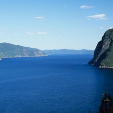
Sentier des Caps, Hiking trail in Rivière-Éternité, Canada

Sentier des Caps is a hiking trail system in the mountains of this region, featuring multiple routes with varying difficulty levels. The paths wind through forested sections and open highland areas with changing views along the way.

The trail network developed from pathways used by Indigenous peoples and early settlers to connect communities along the Saguenay River. These connections shaped how people moved through the region for generations.

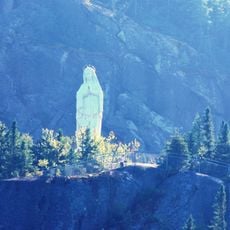
Local guides lead educational tours throughout the trail system, sharing knowledge about Quebec's natural heritage and the region's ecological significance.

The trail network is well marked and accessible, with most sections walkable on foot. Visitors should be prepared for changes in elevation and varying ground conditions.

The trail system includes the Sentier du Lac Gauthier spanning 3 kilometers and Sentier La Faille extending 2.2 kilometers through distinct geological formations.

The community of curious travelers

AroundUs brings together thousands of curated places, local tips, and hidden gems, enriched daily by 60,000 contributors worldwide.

Start exploring
GPS coordinates
48.29222,-70.27917
Latest update
December 15, 2025 13:26
Reviews
Share your experience

No review yet

Discussions
Start a discussion...

No discussion yet

« Sentier des Caps - Hiking trail in Rivière-Éternité, Canada » is provided by Around Us (aroundus.com). Images and texts are derived from Wikimedia project under a Creative Commons license. You are allowed to copy, distribute, and modify copies of this page, under the conditions set by the license, as long as this note is clearly visible.

Discover hidden gems everywhere you go!

From secret cafés to breathtaking viewpoints, skip the crowded tourist spots and find places that match your style. Our app makes it easy with voice search, smart filtering, route optimization, and insider tips from travelers worldwide. Download now for the complete mobile experience.

Around Us App Screenshot

A unique approach to discovering new places

Le Figaro

All the places worth exploring

France Info

A tailor-made excursion in just a few clicks

20 Minutes

Around Us
Travel Guide & Maps
Download

Send to your phone

QR Code
1

Open the camera app on your mobile.

2

Point at the QR code with your camera. A notification will appear.

3

Tap the notification to open the link.