Rautispitz, Mountain summit in Glarus, Switzerland
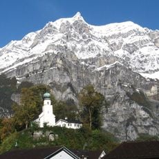
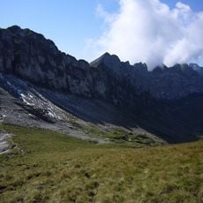
Rautispitz is a 2,283-metre summit in the Schwyzer Alps of the canton of Glarus, standing west above Netstal between the Obersee and the Klöntalersee. It rises about 600 metres north of the one-metre-lower Wiggis, and from the valley the two are seen as a single mountain. The municipal boundary between Näfels and Netstal runs over the summits.
The mountain became a climbing destination during the Alps' systematic exploration in the 19th century, drawing mountaineers from Switzerland and neighboring regions. It has remained a known peak on hiking maps and in Alpine clubs ever since.
The twin peaks Rautispitz and Wiggis are among the classic destinations in the Glarus canton's hiking trail network. Routes start at the Obersee to the north, either via the Rautialp or steeply through the north flank by the Geisskappel; from the south, the steep flank is climbed from the Klöntal. Crossing both summits requires a T4 mountain hiking connection.
Several hiking trails approach the summit from different directions, with the western route from Obersee being the most commonly used. Mountain huts nearby provide lodging and meals for hikers planning longer stays.
The rock at the transition from the neighbouring Wiggis to the Rautispitz turns noticeably white, brittle and schistose, unlike the Jurassic and Cretaceous limestones of the Wiggis itself. The two summits stand about 600 metres apart and are seen from the valley as a single mountain; the municipal boundary between Näfels and Netstal runs over both tops.
The community of curious travelers
AroundUs brings together thousands of curated places, local tips, and hidden gems, enriched daily by 92,634 contributors worldwide.