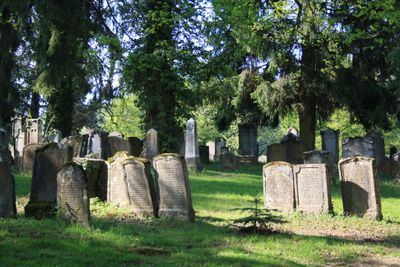
Jewish cemetery, Jewish cemetery in Endingen, Switzerland
The Jewish cemetery in Endingen is Switzerland's largest Jewish burial ground, containing over 2700 graves with headstones oriented in a north-south direction. The site is organized into separate sections that reflect traditional gender divisions in burial practices.
In 1750, the Jewish communities of Endingen and Lengnau purchased a wooded plot to establish this cemetery after flooding affected their previous burial ground. This founding marked a turning point for Jewish burial practices in the region.
The gravestones display inscriptions in Hebrew and German, reflecting the religious and linguistic identity of the communities buried here. This blend of languages on the stones tells the story of a Jewish community that maintained its traditions while living in German-speaking Switzerland.
The cemetery is located at Buckstrasse in Endingen and is accessible during regular visiting hours. Visitors should wear appropriate clothing and maintain quiet behavior to respect the solemn nature of the space.
Before this cemetery was established, the Jewish community buried their dead on a small Rhine River island called Judenäule, with approximately 80 graves later relocated to this site. This move demonstrates how the community adapted to changing circumstances in search of a permanent burial ground.
The community of curious travelers
AroundUs brings together thousands of curated places, local tips, and hidden gems, enriched daily by 60,000 contributors worldwide.