Munt Müsella, Mountain summit in Grisons, Switzerland
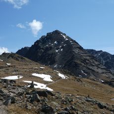
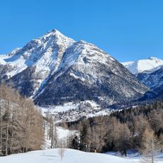
Munt Müsella is the northernmost elevation of the Vadrettgruppe, a subgroup of the Livigno Alps, reaching 2,630 m above sea level. Its broad hump lies on the municipality of La Punt Chamues-ch, framed by Val Chamuera to the northeast, Val Malat to the east, Val Müsella to the south and the Upper Engadin to the northwest. Neighbouring peaks include Piz Utèr (2,966 m) and Piz Malat (2,992 m) to the south.
The name Munt Müsella combines Romansh munt (mountain, alpine meadow) with a diminutive of Late Latin musus, 'snout', echoed in Lombard müs. The peak is the northernmost elevation of the Vadrettgruppe, a subgroup of the Livigno Alps, and lies entirely within the municipality of La Punt Chamues-ch. Its broad hump is framed by Val Chamuera to the northeast, Val Malat to the east, Val Müsella to the south and the Upper Engadin to the northwest.
The name combines Romansh "munt" (mountain, alpine meadow) with Müsella, a diminutive of late Latin musus, "snout" — a reference to the peak's broad, blunt hump. The summit lies on the municipal territory of La Punt Chamues-ch, the usual trailhead, reached via Alp Müsella at 2,196 m.
The usual starting point is La Punt Chamues-ch at 1,686 m; the normal route via Alp Müsella (2,196 m) is rated T3 and takes about 3 hours. There is no lift: the path is partly trackless with only occasional cairns, so good visibility and a sense of direction are needed. The descent can continue southeast to P. 2618 and west to P. 2328, crossing the Ova da Müsella back to Alp Müsella.
The summit's farthest visible point lies 45 km to the southwest, between Monte Gruf and Monte Belegnia above Chiavenna in Italy, at 2,548 m. The name combines Romansh munt (mountain, alpine meadow) with Müsella, a diminutive of late Latin musus (muzzle), echoing Lombard müs.
The community of curious travelers
AroundUs brings together thousands of curated places, local tips, and hidden gems, enriched daily by 93,760 contributors worldwide.