Fernsehturm Stuttgart, Television tower in Degerloch, Germany
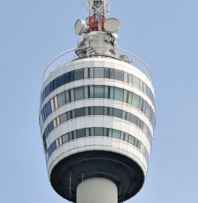
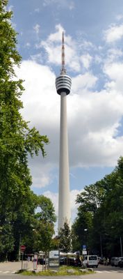
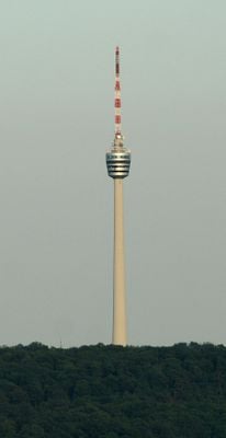
Fernsehturm Stuttgart is a transmission tower in Degerloch, southern Stuttgart, standing 216.61 meters above sea level and housing two observation platforms and a rotating restaurant. The structure consists of a tapering concrete shaft that supports a basket containing visitor facilities, topped by several technical platforms for antennas and broadcasting equipment.
Fritz Leonhardt developed the plans after the Second World War to meet growing demand for television broadcasting across the region, with construction taking place between 1954 and 1956. His approach set new benchmarks for broadcast towers and led to the spread of similar concrete structures around the world in the following decades.
Engineers and architects from around the world studied this structure when it opened, as its slim reinforced concrete shaft introduced a new way to build tall towers without steel frameworks. Visitors today walk through spaces that once sparked a wave of similar designs across Europe, Asia, and Africa during the following decades.
Two elevators bring visitors to the viewing levels at roughly 150 meters height, where clear weather allows views across surrounding hills and forests. Access begins at the entrance near the base, and the platform may close during poor weather or strong winds.
Three rotating xenon lamps above the observation deck shine at night like a lighthouse and serve as a navigation aid for aircraft. The restaurant at 145 meters (476 feet) rotates slowly and completes a full turn in roughly 48 minutes, allowing diners to see the entire panorama during a meal.
Location: Degerloch
Inception: February 5, 1956
Architects: Fritz Leonhardt
Official opening: February 5, 1956
Architectural style: modern architecture
Elevators: 2
Elevation above the sea: 483 m
Height: 216.61 m
Made from material: reinforced concrete
Address: Jahnstraße 120, 70597 Stuttgart, Germany
Opening Hours: Monday-Sunday 10:00-22:00
Phone: +49711232597
Website: https://fernsehturm-stuttgart.de
GPS coordinates: 48.75667,9.19139
Latest update: December 13, 2025 18:34
Weißenburgpark
1.1 km
Kinderstraßenbahn Rumpelstilzchen
924 m
Stuttgart-Degerloch water tower
759 m
Santiago-de-Chile-Platz
1.4 km
Bopserbrunnen
1.3 km
Stolperstein dedicated to Ella Kessler-Reis
1.2 km
Untere Altenbergstaffel (Stuttgart)
1.2 km
Im Kienle (Stuttgart)
862 m
Stolperstein dedicated to Berta Frank
820 m
Stolperstein dedicated to Stefan Salomon Frank
820 m
Waldgebiet auf der Südostseite der Innenstadt
1 km
Am Bopserweg (Stuttgart)
1.2 km
Marmorsaal
1.1 km
Haigstkirche
1.4 km
Stolperstein dedicated to Maria Lemmé
957 m
1 Mammutbaum "steinkopfstr. 6"
829 m
Himmelfahrtsbrunnen
1.2 km
Stolperstein dedicated to Alice Vogel
884 m
Stolperstein dedicated to Richard Vogel
884 m
1 Mammutbaum "Sonnenbergstr. 39"
1.3 km
Steingrübenweg (Stuttgart)
1.4 km
1 Sommerlinde "Im Unteren Kienle 17"
995 m
Biellmann-Pirouette
716 m
Römerstaffel (Stuttgart)
1.2 km
Lehenstaffel (Stuttgart)
1.3 km
Rottannenweg (Stuttgart)
1.1 km
Römerstraße (Stuttgart)
1.2 km
Oberer Reichelenbergweg (Stuttgart)
1.2 kmVisited this place? Tap the stars to rate it and share your experience / photos with the community! Try now! You can cancel it anytime.
Discover hidden gems everywhere you go!
From secret cafés to breathtaking viewpoints, skip the crowded tourist spots and find places that match your style. Our app makes it easy with voice search, smart filtering, route optimization, and insider tips from travelers worldwide. Download now for the complete mobile experience.
A unique approach to discovering new places❞
— Le Figaro
All the places worth exploring❞
— France Info
A tailor-made excursion in just a few clicks❞
— 20 Minutes