Rotstein

Log in to your account

AroundUs is a community-driven map of interesting places, built by curious explorers like you. It grows with every review, story, and photo you share.
Connect to save your favorite spots, contribute locations, and create personalized routes.
By continuing, you accept our Terms and Conditions and our Privacy Policy

Rotstein

Add to collection
Map
Suggest a change
Share

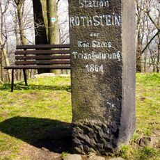
Rotstein, Mountain summit in Saxon Switzerland, Germany.
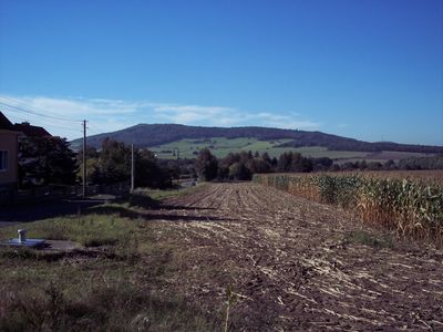
The mountain reaches an elevation of 463 meters and features a combination of forested areas and rocky sections along its slopes.

The summit carries two names, Rotstein in German and Hrodźišćo pola Załomja in Sorbian, reflecting the linguistic heritage of the Saxon region.

The mountain serves as a meeting point for hikers who regularly gather to explore the natural formations and observe the Bohemian Mountains.

A 13.5-kilometer trail leads to the summit, taking approximately four and a half hours to complete with an elevation change of 321 meters.

From the peak, visitors can observe multiple geological formations including Katzstein and Spitzer Stein within the surrounding landscape.

GPS coordinates: 51.10537,14.76502

Latest update: March 28, 2025 22:17

Around this place
Show the full map
Schafberg
Germany

Schafberg

4.7 km
Dorfkirche Herwigsdorf
Germany

Dorfkirche Herwigsdorf

4.1 km
St.-Johannes-Kirche (Reichenbach/O.L.)
Germany

St.-Johannes-Kirche (Reichenbach/O.L.)

4.8 km
Georgenkapelle
Germany

Georgenkapelle

863 m
Bachmannwindmühle Sohland am Rotstein
Germany

Bachmannwindmühle Sohland am Rotstein

2.4 km
Rotstein
Germany

Rotstein

624 m
Dorfkirche Bischdorf
Germany

Dorfkirche Bischdorf

2 km
Industriemühle; Industriemühle mit Mühlentechnik und Bruchsteinbrücke Badergasse 5
Germany

Industriemühle; Industriemühle mit Mühlentechnik und Bruchsteinbrücke Badergasse 5

4.8 km
Sächsisch-Preußischer Grenzstein: Pilarpaar Nr. 28 (rechtselbisch)
Germany

Sächsisch-Preußischer Grenzstein: Pilarpaar Nr. 28 (rechtselbisch)

4.8 km
Windmühle am Mittelgut
Germany

Windmühle am Mittelgut

1.9 km
Eisenbahnstrecke Dresden - Görlitz; Brücke Sohland; Eisenbahnviadukt über das Tal des Schwarzen Schöps
Germany

Eisenbahnstrecke Dresden - Görlitz; Brücke Sohland; Eisenbahnviadukt über das Tal des Schwarzen Schöps

2.9 km
Windmühle auf dem Töpferberg
Germany

Windmühle auf dem Töpferberg

4.7 km
Buschmühle Bellwitz
Germany

Buschmühle Bellwitz

4.6 km
Einzeldenkmale o. g. Sachgesamtheit: Westliches Stallgebäude (Bau rechts der Hofeinfahrt), südliches Stallgebäude, vorderer Teil Nr. 4 als Wohnhaus ausgebaut und ein Steintrog (siehe auch Sachgesamtheitsdokument - obj 09304290, gleiche Anschrift)
Germany

Einzeldenkmale o. g. Sachgesamtheit: Westliches Stallgebäude (Bau rechts der Hofeinfahrt), südliches Stallgebäude, vorderer Teil Nr. 4 als Wohnhaus ausgebaut und ein Steintrog (siehe auch Sachgesamtheitsdokument - obj 09304290, gleiche Anschrift)

4 km
Sächsisch-Preußischer Grenzstein: Pilarpaar Nr. 26 (rechtselbisch)
Germany

Sächsisch-Preußischer Grenzstein: Pilarpaar Nr. 26 (rechtselbisch)

5.1 km
Reichenbach 700-Jahre-Gedenkstein
Germany

Reichenbach 700-Jahre-Gedenkstein

4.4 km
Station 42 Rothstein
Germany

Station 42 Rothstein

21 m
Niederhofstraße 1, 2, 3, 4, 5, 10
Germany

Niederhofstraße 1, 2, 3, 4, 5, 10

3.3 km
Manor estate Nieder Herwigsdorf
Germany

Manor estate Nieder Herwigsdorf

3.2 km
Sächsisch-Preußischer Grenzstein: Pilarpaar Nr. 32
Germany

Sächsisch-Preußischer Grenzstein: Pilarpaar Nr. 32

4.4 km
Reichenbach, Bahnhofstraße 3
Germany

Reichenbach, Bahnhofstraße 3

4.4 km
Sächsisch-Preußischer Grenzstein: Pilar Nr. 27 (rechtselbisch)
Germany

Sächsisch-Preußischer Grenzstein: Pilar Nr. 27 (rechtselbisch)

4.7 km
Einzeldenkmal o. g. Sachgesamtheit: Rittergut mit Schloss und zwei Wirtschaftsgebäuden an der Straße sowie Mühle (Nr. 6 und 7) (siehe auch Sachgesamtheitsdokument - Obj. 09303875, gleiche Anschrift) Untere Dorfstraße 2; 2a; 2b; 3; 4; 6; 7
Germany

Einzeldenkmal o. g. Sachgesamtheit: Rittergut mit Schloss und zwei Wirtschaftsgebäuden an der Straße sowie Mühle (Nr. 6 und 7) (siehe auch Sachgesamtheitsdokument - Obj. 09303875, gleiche Anschrift) Untere Dorfstraße 2; 2a; 2b; 3; 4; 6; 7

2.1 km
Sächsisch-Preußischer Grenzstein: Pilarpaar Nr. 29 (rechtselbisch)
Germany

Sächsisch-Preußischer Grenzstein: Pilarpaar Nr. 29 (rechtselbisch)

4.6 km
Sächsisch-Preußischer Grenzstein: Pilarpaar Nr. 30 (rechtselbisch)
Germany

Sächsisch-Preußischer Grenzstein: Pilarpaar Nr. 30 (rechtselbisch)

4.5 km
Rittergut Niederbischdorf
Germany

Rittergut Niederbischdorf

2.1 km
Rittergut Wendisch-Paulsdorf Wendisch-Paulsdorf, Am Hof 15; 18
Germany

Rittergut Wendisch-Paulsdorf Wendisch-Paulsdorf, Am Hof 15; 18

4 km
Rittergut Obermittelherwigsdorf (Sachgesamtheit) Mittelhofweg 1; 2; 3; 4
Germany

Rittergut Obermittelherwigsdorf (Sachgesamtheit) Mittelhofweg 1; 2; 3; 4

4 km
Show the full map

Reviews

Visited this place? Tap the stars to rate it and share your experience / photos with the community! Try now! You can cancel it anytime.

« Rotstein: Mountain summit in Saxon Switzerland, Germany » is provided by Around Us (aroundus.com). Images and texts are derived from Wikimedia project under a Creative Commons license. You are allowed to copy, distribute, and modify copies of this page, under the conditions set by the license, as long as this note is clearly visible.

Discover hidden gems everywhere you go!

From secret cafés to breathtaking viewpoints, skip the crowded tourist spots and find places that match your style. Our app makes it easy with voice search, smart filtering, route optimization, and insider tips from travelers worldwide. Download now for the complete mobile experience.

Around Us App Screenshot

A unique approach to discovering new places

Le Figaro

All the places worth exploring

France Info

A tailor-made excursion in just a few clicks

20 Minutes