Chest opened
+${chestReward.xp} XP
Explorer
NOUVEAU ×${chestReward.collectible.quantity}
tapez pour fermer

See the monuments around you in AR Open chests in the app

Around Us is built for your phone — point your camera at the streets and discover the monuments and places around you in augmented reality. Around Us is built for your phone — chests unlock when you walk, explore and capture nearby places.

•

Enable Location

We need your location to show you interesting places around you

Discover nearby places

Find interesting locations and hidden gems around you

Precise directions

Get accurate directions and distances to places

Your location is never shared with other users. It's only used when you tap the location button.

Dittersdorfer Höhe

Log in to your account

Start exploring — it's free

Trusted by 94,572 travelers worldwide

Continue with Google
Continue with Apple
or

We will send you a code to connect

By continuing, you accept our Terms and Conditions and our Privacy Policy

Check your inbox

We've sent a pincode in your inbox. Please enter the code below.

Dittersdorfer Höhe

Dittersdorfer Höhe, Mountain summit and scenic viewpoint in Amtsberg, Erzgebirgskreis, Germany.

Dittersdorfer Höhe is a summit with a viewpoint situated at 553 meters elevation in the Erzgebirge range. From this vantage point, visitors look out across valleys and forested slopes toward the city of Chemnitz in the distance.

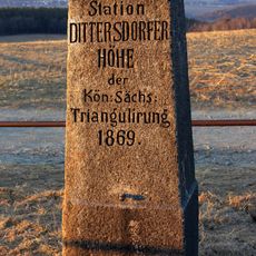
In 1869 a station of the Royal Saxon Triangulation was built on the ridge of the Dittersdorfer Höhe, one of the survey points used to map the kingdom. Around 1900 an excursion inn was opened southwest of and below the plateau; after several conversions and extensions it now houses a hotel with a restaurant.

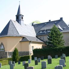
The excursion inn built around 1900 below the plateau, southwest of the summit, has been rebuilt and extended several times and now houses a hotel with restaurant. The hill gave its name to the Dittersdorf district of Amtsberg below it, and the inn remains the stopping point for walkers on the ridge.

Multiple hiking trails connect to the summit, ranging from short walks to longer mountain routes. The location is accessible from several nearby villages and offers rest areas and refreshment options.

On the ridge stands a station of the Royal Saxon Triangulation built in 1869, a surveying marker from the kingdom's mapping of Saxony. The quartzite schist lenses on the north slope were quarried in the past for gravel.

The community of curious travelers

AroundUs brings together thousands of curated places, local tips, and hidden gems, enriched daily by 94,572 contributors worldwide.

Start exploring
Accessibility
Wheelchair inaccessible
GPS coordinates
50.76272,13.00744
Latest update
October 25, 2026 00:40
Around this place
Einsiedler Brauhaus
Germany

Einsiedler Brauhaus

1.4 mi
Einsiedel Dam
Germany

Einsiedel Dam

1.4 mi
Ehemaliges Rathaus, Einsiedler Hauptstraße 79a; 79b Chemnitz-Einsiedel
Germany

Ehemaliges Rathaus, Einsiedler Hauptstraße 79a; 79b Chemnitz-Einsiedel

1.6 mi
St. Jacobi Chemnitz-Einsiedel, Sachgesamtheit einzelner Denkmäler
Germany

St. Jacobi Chemnitz-Einsiedel, Sachgesamtheit einzelner Denkmäler

1.6 mi
Sachgesamtheit Talsperre Einsiedel Altenhainer Allee
Germany

Sachgesamtheit Talsperre Einsiedel Altenhainer Allee

1.5 mi
Wohnstallhaus und Seitengebäude eines Vierseithofes Einsiedler Weg 2
Germany

Wohnstallhaus und Seitengebäude eines Vierseithofes Einsiedler Weg 2

1.6 mi
Ortschaftsverwaltung Kleinolbersdorf-Altenhain
Germany

Ortschaftsverwaltung Kleinolbersdorf-Altenhain

1.6 mi
Staumauer und weitere Bauwerke der Talsperre Einsiedel Altenhainer Allee
Germany

Staumauer und weitere Bauwerke der Talsperre Einsiedel Altenhainer Allee

1.5 mi
Sachgesamtheit Dorfkirche St. Jacobi Einsiedel Harthauer Weg
Germany

Sachgesamtheit Dorfkirche St. Jacobi Einsiedel Harthauer Weg

1.6 mi
Grundschule Einsiedel
Germany

Grundschule Einsiedel

1.6 mi
Christuskirche
Germany

Christuskirche

1.1 mi
Evangelische Pfarrkirche Dittersdorf
Germany

Evangelische Pfarrkirche Dittersdorf

0.8 mi
Denkmal für die Gefallenen des Ersten Weltkriegs, bei Altenhainer Dorfstraße 45
Germany

Denkmal für die Gefallenen des Ersten Weltkriegs, bei Altenhainer Dorfstraße 45

1.6 mi
Wohnstallhaus und Seitengebäude eines Bauernhofes Altenhainer Dorfstraße 47
Germany

Wohnstallhaus und Seitengebäude eines Bauernhofes Altenhainer Dorfstraße 47

1.6 mi
Dreiseithof mit Wohnstallhaus, Scheune und Stall Einsiedler Weg 1
Germany

Dreiseithof mit Wohnstallhaus, Scheune und Stall Einsiedler Weg 1

1.5 mi
Altenhainer Dorfstraße 51, Chemnitz-Altenhain
Germany

Altenhainer Dorfstraße 51, Chemnitz-Altenhain

1.6 mi
Uhlig-Gedenkstein, Chemnitz-Altenhain
Germany

Uhlig-Gedenkstein, Chemnitz-Altenhain

1.6 mi
Am Winkel 2, Chemnitz-Altenhain
Germany

Am Winkel 2, Chemnitz-Altenhain

1.5 mi
Gasthof Goldener Hahn, Chemnitz-Altenhain
Germany

Gasthof Goldener Hahn, Chemnitz-Altenhain

1.5 mi
Mietshaus mit Gaststätte und Vorgarten, in Ecklage; Altenhainer Allee 8 (mit Anton-Herrmann-Straße 2)
Germany

Mietshaus mit Gaststätte und Vorgarten, in Ecklage; Altenhainer Allee 8 (mit Anton-Herrmann-Straße 2)

1.5 mi
Wohnhaus in offener Bebauung mit Vorgarten und Einfriedung Anton-Herrmann-Straße 33
Germany

Wohnhaus in offener Bebauung mit Vorgarten und Einfriedung Anton-Herrmann-Straße 33

1.3 mi
Einsiedler Hauptstraße 133, Chemnitz-Einsiedel
Germany

Einsiedler Hauptstraße 133, Chemnitz-Einsiedel

1.4 mi
Brunnenhaus der Brauerei Chemnitz-Einsiedel
Germany

Brunnenhaus der Brauerei Chemnitz-Einsiedel

1.4 mi
Kirchgasse 6, Chemnitz-Einsiedel
Germany

Kirchgasse 6, Chemnitz-Einsiedel

1.6 mi
Station 91 Dittersdorfer Höhe
Germany

Station 91 Dittersdorfer Höhe

0 ft
Rittergut Dittersdorf
Germany

Rittergut Dittersdorf

1.5 mi
Kriegerdenkmal für die Gefallenen des Krieges 1870/71 Kirchsteig -
Germany

Kriegerdenkmal für die Gefallenen des Krieges 1870/71 Kirchsteig -

0.8 mi
Pfarrhaus mit daran angebauter Kapelle Eisenstraße 4
Germany

Pfarrhaus mit daran angebauter Kapelle Eisenstraße 4

1.7 mi
Show the full map
Reviews
Share your experience

No review yet

Discussions
Start a discussion...

No discussion yet

« Dittersdorfer Höhe - Mountain summit and scenic viewpoint in Amtsberg, Erzgebirgskreis, Germany » is provided by Around Us (aroundus.com). Images and texts are derived from Wikimedia project under a Creative Commons license. You are allowed to copy, distribute, and modify copies of this page, under the conditions set by the license, as long as this note is clearly visible.

Discover hidden gems everywhere you go!

From secret cafés to breathtaking viewpoints, skip the crowded tourist spots and find places that match your style. Our app makes it easy with voice search, smart filtering, route optimization, and insider tips from travelers worldwide. Download now for the complete mobile experience.

Around Us App Screenshot
❝

A unique approach to discovering new places❞

— Le Figaro

❝

All the places worth exploring❞

— France Info

❝

A tailor-made excursion in just a few clicks❞

— 20 Minutes

Around Us
Travel Guide & Maps
Download

Send to your phone

QR Code
1

Open the camera app on your mobile.

2

Point at the QR code with your camera. A notification will appear.

3

Tap the notification to open the link.