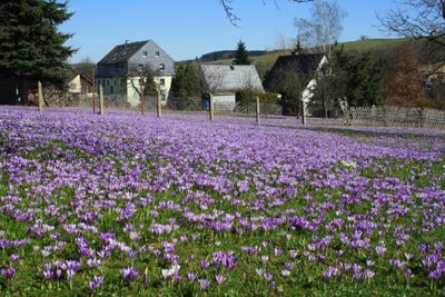
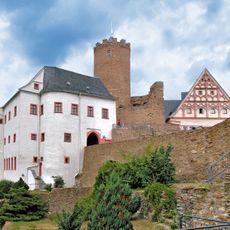
Drebacher Krokuswiesen, Natural monument in Drebach, Germany.
The Drebach Crocus Meadows comprise a protected natural area with multiple sections where wild spring flowers flourish. The site spreads across rolling terrain and displays dense blooms in varying shades during spring months.
The crocus population here traces back to the 1600s when a local pastor received a small gift of bulbs from a botanical collection. This initial planting eventually developed into the protected flower landscape visible today.
The meadows draw people together during the blooming season as a place to experience spring arriving. Local gatherings happen regularly, connecting visitors with this special corner of the landscape.
The best time to visit falls between March and April when the flowers are most abundant and visible. Sturdy footwear is recommended as the ground can become muddy depending on recent weather conditions.
The flowers push directly from the ground and often break through the final snow cover of winter. This resilience makes them a symbol of spring's arrival in a landscape still locked in cold.
Location: Drebach
GPS coordinates: 50.68278,13.02611
Latest update: December 12, 2025 14:20
Scharfenstein Castle
3.2 km
Scharfenstein Castle
3.2 km
Drebach Observatory
1.4 km
St.-Bartholomäus-Kirche
4.1 km
Oberes Zschopautal mit Preßnitztal
3.5 km
Kirche Zum Heiligen Kreuz
3 km
Rittergut Venusberg
2 km
Straßenbrücke über die Zschopau Scharfenstein
3.3 km
Kirche Schönbrunn
3.7 km
Methodistenkirche Hauptstraße 75
1.1 km
Kgl.-sächs. Postmeilenstein Herold
2.9 km
Burg mit Toranlage, Brücke und Burgmauern (siehe Sachgesamtheitsliste ID 09305763, Schloßberg 1) Schloßberg 1
3.2 km
Burg mit Toranlage, Brücke und Burgmauern und zwei ehemalige Wirtschaftsgebäude eines Rittergutes, Schlosspark (Gartendenkmal) nördlich der Burg, weiterhin mit Nebengebäude am Schloss (Schloßberg 2) und Nebengebäude am Wirtschaftshof (Hofgasse
3.2 km
Rittergut Drebach
699 m
Kirche (mit Ausstattung), Kirchhof mit zwei Grabmalen und Einfriedung Venusberger Straße 12b
717 m
Kalkwerk Herold (Sachgesamtheit) Herold
3.2 km
Ehemalige Schule Uferstraße 4
2.2 km
Polish-Saxon Post Milestone Wolkenstein
4 km
Ambrossgut Schönbrunn
3.7 km
Rosskastanie
4.1 km
DDR-Museum Gelenau
3.9 km
Venusberg concentration camp memorial
2.9 km
Villa mit Villengarten und Einfriedung Bahnhofstraße 7
4 km
Bahnhof Gelenau
3.8 km
Gedenkstein für Helmut von Moltke, 1937 auf Anton Günther übertragen
3.4 km
Herrenhaus, daran angebautes Wirtschaftsgebäude und Taubenhaus eines Rittergutes sowie Teich am Herrenhaus Herolder Straße 2
2 km
Bahnhof Scharfenstein Scharfenstein
3.1 km
Kalkwerk Herold (Sachgesamtheit) Herold
3.2 kmVisited this place? Tap the stars to rate it and share your experience / photos with the community! Try now! You can cancel it anytime.
Discover hidden gems everywhere you go!
From secret cafés to breathtaking viewpoints, skip the crowded tourist spots and find places that match your style. Our app makes it easy with voice search, smart filtering, route optimization, and insider tips from travelers worldwide. Download now for the complete mobile experience.
A unique approach to discovering new places❞
— Le Figaro
All the places worth exploring❞
— France Info
A tailor-made excursion in just a few clicks❞
— 20 Minutes