Murrtalviaduct, Road viaduct in Backnang, Germany.
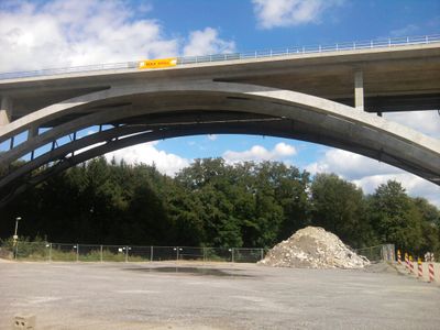
The Murrtalviaduct is a road bridge spanning the Murr River valley with a total length of 394 meters, divided into ten continuous sections supported by concrete arches. The construction uses a semi-integral design that distributes loads evenly across multiple supports.
An earlier viaduct stood at this location starting in 1937, serving as a bypass for Backnang on the Reichsstrasse 14. The original structure was destroyed in 1945 and later replaced with a modern rebuild.
The structure is an important part of the transport network that connects the Stuttgart region with Backnang and surrounding communities. It shapes the landscape and demonstrates how engineers create passageways across challenging terrain.
The viaduct sits on the B-14 federal highway and connects the Stuttgart region directly to Backnang for through traffic. The eastern section is currently under expansion, which may cause traffic delays, so patience is advisable when traveling.
The structure connects both directions through a special semi-integral design that seamlessly ties the eastern and western sections together. This approach allows long spans to be bridged without extra intermediate elements.
The community of curious travelers
AroundUs brings together thousands of curated places, local tips, and hidden gems, enriched daily by 60,000 contributors worldwide.