Chest opened
+${chestReward.xp} XP
Explorer
NOUVEAU ×${chestReward.collectible.quantity}
tapez pour fermer

See the monuments around you in AR Open chests in the app

Around Us is built for your phone — point your camera at the streets and discover the monuments and places around you in augmented reality. Around Us is built for your phone — chests unlock when you walk, explore and capture nearby places.

•

Enable Location

We need your location to show you interesting places around you

Discover nearby places

Find interesting locations and hidden gems around you

Precise directions

Get accurate directions and distances to places

Your location is never shared with other users. It's only used when you tap the location button.

Geiseltalsee

Log in to your account

Start exploring — it's free

Trusted by 92,853 travelers worldwide

Continue with Google
Continue with Apple
or

We will send you a code to connect

By continuing, you accept our Terms and Conditions and our Privacy Policy

Check your inbox

We've sent a pincode in your inbox. Please enter the code below.

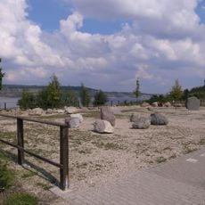
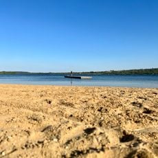
Geiseltalsee, Artificial lake in Saalekreis, Germany

Geiseltalsee is a flooded former lignite opencast mine in the Geiseltal valley, with a surface of 18.4 square kilometres and a maximum depth of 78 metres. It holds about 0.423 cubic kilometres of water, making it Germany's largest artificial lake by area until the Cottbuser Ostsee is fully flooded. Its irregular shoreline of wooded peninsulas and coves lies between Mücheln and Braunsbedra.

Lignite was documented in the Geiseltal from 1698, but large-scale opencast mining began only around 1905/06, with pits such as Elisabeth, Rheinland and Cecilie opening from 1907. Opencast operations ended on 30 June 1993 after 1.4 billion tonnes of lignite had been extracted, and 18 settlements were destroyed with about 12,500 people resettled. Flooding with water from the Saale began on 30 June 2003 and was completed in 2011.

The Geiseltal valley gave its name to the lake and was known for its Eocene fossil beds, exposed by the lignite mine. On about 30 hectares of the northern shore, the Goldener Steiger vineyard was planted, with a Straußwirtschaft wine tavern. The shore slopes are grazed by Rotes Höhenvieh, an endangered cattle breed.

The lake is bordered by Mücheln to the southwest, west and northwest, Braunsbedra to the northeast, east and southeast, and Bad Lauchstädt along a short stretch to the northwest. Three roughly 14-metre observation towers stand near the shore: Seeblick on the Klobikau spoil tip, Leonhardt just north of Neumark, and Pauline near Stöbnitz, 1 km north of the marina there. The water level is held at 98.05 m above sea level by the Frankleben outflow structure.

The lake bed is the former opencast mine of the Geiseltal, where the fossil record made the valley famous; the pit was about 80 metres deep and covered some 2,600 hectares before flooding. Water from the Saale is still added because the fractured mining subsoil loses water through seepage.

The community of curious travelers

AroundUs brings together thousands of curated places, local tips, and hidden gems, enriched daily by 92,853 contributors worldwide.

Start exploring
Location
Elevation above the sea
98.05 m
GPS coordinates
51.31728,11.86384
Latest update
October 26, 2026 13:10
Reviews
Share your experience

No review yet

Discussions
Start a discussion...

No discussion yet

« Geiseltalsee - Artificial lake in Saalekreis, Germany » is provided by Around Us (aroundus.com). Images and texts are derived from Wikimedia project under a Creative Commons license. You are allowed to copy, distribute, and modify copies of this page, under the conditions set by the license, as long as this note is clearly visible.

Discover hidden gems everywhere you go!

From secret cafés to breathtaking viewpoints, skip the crowded tourist spots and find places that match your style. Our app makes it easy with voice search, smart filtering, route optimization, and insider tips from travelers worldwide. Download now for the complete mobile experience.

Around Us App Screenshot
❝

A unique approach to discovering new places❞

— Le Figaro

❝

All the places worth exploring❞

— France Info

❝

A tailor-made excursion in just a few clicks❞

— 20 Minutes

Around Us
Travel Guide & Maps
Download

Send to your phone

QR Code
1

Open the camera app on your mobile.

2

Point at the QR code with your camera. A notification will appear.

3

Tap the notification to open the link.