Kleiner Bärenstein, Sandstone summit in Sächsische Schweiz-Osterzgebirge, Germany.
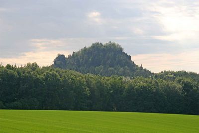
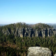
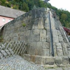
Kleiner Bärenstein is a sandstone summit in Saxon Switzerland that rises alongside its larger neighbor to form a distinctive rocky mass. The peak is surrounded by steep slopes and provides wide views across the forested landscape of the region.
The summit was first documented in writing in 1548 under the name 'im Behrenstein'. Over the following centuries, it gradually became a recognized landmark in the exploration of this mountain region.
District forester Wilhelm Mahn developed hiking paths around Kleiner Bärenstein during the 19th century, establishing the mountain's role in outdoor recreation.
Multiple marked hiking trails approach the summit from different directions and connect with nearby villages of Thürmsdorf and Naundorf. The walks are moderately challenging and require good footwear due to the rocky terrain.
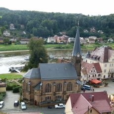
From the north side of the mountain you look out toward Stadt Wehlen, while the south side overlooks the medieval Königstein castle far below. These two contrasting views make the summit a natural vantage point for seeing both the historic structures and surrounding landscape in one visit.
Location: Sächsische Schweiz-Osterzgebirge
Elevation above the sea: 337.7 m
GPS coordinates: 50.94216,14.04511
Latest update: December 13, 2025 11:42
Großer Bärenstein
471 m
Stadt Wehlen station
1.6 km
Sachgesamtheit Rittergut Thürmsdorf mit folgenden Einzeldenkmalen: Schlosskomplex und zwei Skulpturen im Park (siehe Einzeldenkmalliste - Obj. 09224693), das Mausoleum der Familie Biedermann östlich des Gutskomplexes (siehe Einzeldenkmalliste - Obj
1.3 km
Wohnhaus in offener Bebauung Mennickestraße 1
1.8 km
Stadtkirche Wehlen
1.8 km
Robert-Sterl-Haus
1.4 km
Residential building (with two house parts) in open development Kirchstraße 4
1.8 km
Residential building in open development, formerly hotel, with later extension Markt 1
1.8 km
Wohnhaus Bahnhofstraße 3
1.6 km
Schloss Thürmsdorf
1.3 km
Landhaus, angebautes Nebengebäude und Grabmal Ehepaar Sterl, dazu parkähnlicher Garten mit Wegesystem, Baumbestand und Einfriedung Robert-Sterl-Straße 30
1.4 km
Wohnhaus in offener Bebauung mit Einfriedungsmauer Robert-Sterl-Straße 14
1.5 km
Wohnhaus in halboffener Bebauung und Hinterhaus Kirchstraße 9
1.9 km
Wohnhaus in offener Bebauung, mit Anbau Rathener Weg 3
1.6 km
Hotel building (with café) in open development Karl-Marx-Platz 4
1.8 km
Residential building in semi-open development Market 8
1.8 km
Hotel building (with restaurant) in open development Market 9
1.8 km
Wohnhaus in offener Bebauung, ehemaliges Hotel und Café (ursprünglich zwei Hausteile), mit Terrasse zur Elbe Kirchstraße 6; 8
1.8 km
Wohnhaus (Umgebinde) in halboffener Bebauung Mennickestraße 11
1.8 km
Eisbarriere Mennickestraße 18 (vor)
1.8 km
Wohnhaus in offener Bebauung Mennickestraße 26
1.8 km
Wohnhaus in offener Bebauung Bahnhofstraße 15
1.6 km
Brücke über den Uttewalder Grundbach Karl-Marx-Platz 4 (bei)
1.8 km
Biedermann-Mausoleum
1.3 km
Ehemaliges Wohnstallhaus, später Gasthaus, mit Anbauten und Kellergewölbe Bahnhofstraße 4
1.6 km
Residential house (former flax dyeing factory) in corner location, with annex Rosenstraße 1
1.8 km
Rahmmühle; Niedere Pehnamühle Thürmsdorf
1.6 km
Zwei Wohnhäuser Am Sonnenhang 2
896 mVisited this place? Tap the stars to rate it and share your experience / photos with the community! Try now! You can cancel it anytime.
Discover hidden gems everywhere you go!
From secret cafés to breathtaking viewpoints, skip the crowded tourist spots and find places that match your style. Our app makes it easy with voice search, smart filtering, route optimization, and insider tips from travelers worldwide. Download now for the complete mobile experience.
A unique approach to discovering new places❞
— Le Figaro
All the places worth exploring❞
— France Info
A tailor-made excursion in just a few clicks❞
— 20 Minutes