Enable Location

We need your location to show you interesting places around you

Discover nearby places

Find interesting locations and hidden gems around you

Precise directions

Get accurate directions and distances to places

Your location is never shared with other users. It's only used when you tap the location button.

Talsperre Kauscha

Log in to your account

Start exploring — it's free

Trusted by 63,533 travelers worldwide

Continue with Google
Continue with Apple
or

We will send you a code to connect

By continuing, you accept our Terms and Conditions and our Privacy Policy

Check your inbox

We've sent a pincode in your inbox. Please enter the code below.

Talsperre Kauscha
Discussion Reviews 1 Photos
1.2k Popularity

Talsperre Kauscha, architectural structure

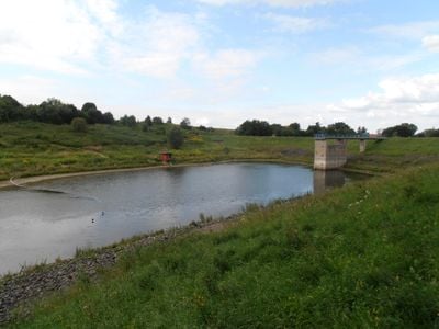
Talsperre Kauscha is an earth dam made of loam soil, approximately 13 meters (43 feet) high and 150 meters (490 feet) long, spanning a broad valley. The dam was constructed between 1983 and 1985, becoming operational in 1987, and holds back water from Geberbach stream with a storage capacity of roughly 270,000 cubic meters.

The dam was built between 1983 and 1985 in response to flooding risks threatening Dresden and began operation in 1987. Minor leaks discovered during testing were repaired in 1997, after which the structure has operated reliably ever since.

The reservoir bears the name of the nearby Kauscha district and serves local residents as a symbol of flood protection infrastructure. The site offers visitors a view of how human engineering blends with the natural landscape, where quiet water and green banks create a peaceful rural setting.

The dam sits adjacent to the busy A17 highway connecting Dresden to Prague, making it easy to locate from surrounding roads. Visitors can observe the structure and reservoir from nearby vantage points, with footpaths along the dam top available for walking and monitoring inspection routes.

An annual function test is performed here where the spillway gate is opened to verify operational readiness, creating a noticeable increase in water flow downstream. This regular check, typically conducted in winter or early spring, serves as a visible reminder to locals and observers of the dam's ongoing maintenance and safety protocols.

The community of curious travelers

AroundUs brings together thousands of curated places, local tips, and hidden gems, enriched daily by 60,000 contributors worldwide.

Start exploring
Location
GPS coordinates
50.98970,13.77720
Latest update
February 9, 2026 07:45
Around this place
Kreisgrabenanlage Dresden-Nickern
Germany

Kreisgrabenanlage Dresden-Nickern

704 m
Schloss Nickern
Germany

Schloss Nickern

832 m
Naturdenkmal Stieleiche Kauscha
Germany

Naturdenkmal Stieleiche Kauscha

313 m
Gedenkstein für Bombenopfer des 13. Februar 1945
Germany

Gedenkstein für Bombenopfer des 13. Februar 1945

968 m
Einheitsbäume
Germany

Einheitsbäume

971 m
Wohnstallhaus eines Bauernhofes und Toranlage (zwei Torpfeiler und Pforte) Dorfstraße 18
Germany

Wohnstallhaus eines Bauernhofes und Toranlage (zwei Torpfeiler und Pforte) Dorfstraße 18

1.3 km
Zwei Wohnstallhäuser (über winkelförmigem Grundriss), Scheune, Hofmauer mit Toreinfahrt und zwei Pforten sowie Stützmauern der Vorgärten eines Vierseithofes, ehemals wohl Vorwerk Goppelner Hauptstraße 1
Germany

Zwei Wohnstallhäuser (über winkelförmigem Grundriss), Scheune, Hofmauer mit Toreinfahrt und zwei Pforten sowie Stützmauern der Vorgärten eines Vierseithofes, ehemals wohl Vorwerk Goppelner Hauptstraße 1

973 m
Ehemalige Schule Golberoder Straße 4
Germany

Ehemalige Schule Golberoder Straße 4

1 km
Wohnstallhaus, Stallgebäude, Scheune und Toranlage (Torbogen und Pforte) eines Dreiseithofes Gebergrundblick 55
Germany

Wohnstallhaus, Stallgebäude, Scheune und Toranlage (Torbogen und Pforte) eines Dreiseithofes Gebergrundblick 55

1.1 km
Wohnstallhaus (Nr. 12, auf Hakengrundriss), Seitengebäude (Nr. 10) und Toranlage (Torbogen und Pforte) eines Bauernhofes Dorfstraße 10; 12
Germany

Wohnstallhaus (Nr. 12, auf Hakengrundriss), Seitengebäude (Nr. 10) und Toranlage (Torbogen und Pforte) eines Bauernhofes Dorfstraße 10; 12

1.2 km
Wohnstallhaus (über Hakengrundriss), Scheune und Torpfeiler eines Bauernhofes Goppelner Hauptstraße 7
Germany

Wohnstallhaus (über Hakengrundriss), Scheune und Torpfeiler eines Bauernhofes Goppelner Hauptstraße 7

1.2 km
Wohnstallhaus, Scheune und Einfriedungsmauer eines Bauernhofes Am Rundling 2
Germany

Wohnstallhaus, Scheune und Einfriedungsmauer eines Bauernhofes Am Rundling 2

1.2 km
Wohnstallhaus (Nr. 4) mit angebautem Seitengebäude (Nr. 4a) und Toranlage eines Zweiseithofes Am Rundling 4; 4a
Germany

Wohnstallhaus (Nr. 4) mit angebautem Seitengebäude (Nr. 4a) und Toranlage eines Zweiseithofes Am Rundling 4; 4a

1.1 km
Wohnstallhaus (mit Anbau) und Seitengebäude sowie Torbogen und Inschrifttafel eines Bauernhofes Gebergrundblick 53
Germany

Wohnstallhaus (mit Anbau) und Seitengebäude sowie Torbogen und Inschrifttafel eines Bauernhofes Gebergrundblick 53

1.1 km
Wohnhaus, daran angebautes Seitengebäude, Scheune, Stallgebäude und Hofmauer mit Toreinfahrt und Pforte eines Vierseithofes Babisnauer Weg 6
Germany

Wohnhaus, daran angebautes Seitengebäude, Scheune, Stallgebäude und Hofmauer mit Toreinfahrt und Pforte eines Vierseithofes Babisnauer Weg 6

1.2 km
Wohnstallhaus, Seitengebäude, Scheune und Auszugshaus sowie Reste der Toreinfahrt eines Vierseithofes Babisnauer Weg 4
Germany

Wohnstallhaus, Seitengebäude, Scheune und Auszugshaus sowie Reste der Toreinfahrt eines Vierseithofes Babisnauer Weg 4

1.2 km
Kreuzstein Babisnauer Weg
Germany

Kreuzstein Babisnauer Weg

1.3 km
Einfriedungsmauer Nickerner Weg 6
Germany

Einfriedungsmauer Nickerner Weg 6

1 km
Wohnhaus, Seitengebäude und Scheune eines Bauernhofes sowie Toranlage (Torpfeiler und Pforte) vom Dorfplatz und rückwärtiger Torbogen an der Scheune sowie Einfriedungsmauer des Gartens südwestlich hinter der Scheune Am Rundling 7
Germany

Wohnhaus, Seitengebäude und Scheune eines Bauernhofes sowie Toranlage (Torpfeiler und Pforte) vom Dorfplatz und rückwärtiger Torbogen an der Scheune sowie Einfriedungsmauer des Gartens südwestlich hinter der Scheune Am Rundling 7

1.2 km
Wegestein Sobrigau
Germany

Wegestein Sobrigau

1 km
Wohnhaus und Toranlage (Torbogen und Pforte) eines Bauernhofes Am Rundling 6
Germany

Wohnhaus und Toranlage (Torbogen und Pforte) eines Bauernhofes Am Rundling 6

1.1 km
Wohnstallhaus eines Bauernhofes Am Rundling 15
Germany

Wohnstallhaus eines Bauernhofes Am Rundling 15

1.1 km
Wohnhaus, Scheune und Toranlage eines Bauernhofes sowie Einfriedungsmauer des Gartens südwestlich hinter der Scheune Am Rundling 13
Germany

Wohnhaus, Scheune und Toranlage eines Bauernhofes sowie Einfriedungsmauer des Gartens südwestlich hinter der Scheune Am Rundling 13

1.1 km
Wohnhaus, Seitengebäude, Scheune und Toranlage eines Bauernhofes sowie Einfriedungsmauer des Gartens südwestlich hinter der Scheune Am Rundling 11
Germany

Wohnhaus, Seitengebäude, Scheune und Toranlage eines Bauernhofes sowie Einfriedungsmauer des Gartens südwestlich hinter der Scheune Am Rundling 11

1.2 km
Gasthof Sobrigau mit Hauptgebäude, Rückgebäude und Seitengebäude Am Rundling 10; 10a
Germany

Gasthof Sobrigau mit Hauptgebäude, Rückgebäude und Seitengebäude Am Rundling 10; 10a

1.1 km
Scheune eines Zweiseithofes und Einfriedungsmauer des Gartens südwestlich hinter der Scheune Am Rundling 9
Germany

Scheune eines Zweiseithofes und Einfriedungsmauer des Gartens südwestlich hinter der Scheune Am Rundling 9

1.2 km
Wohnstallhaus eines Bauernhofes Am Rundling 8
Germany

Wohnstallhaus eines Bauernhofes Am Rundling 8

1.1 km
Wohnstallhaus, Scheune, Stallgebäude und Toranlage (Torbogen und Pforte) eines Dreiseithofes Dorfstraße 16
Germany

Wohnstallhaus, Scheune, Stallgebäude und Toranlage (Torbogen und Pforte) eines Dreiseithofes Dorfstraße 16

1.2 km
Show the full map
Reviews
Share your experience

No review yet

Discussions
Start a discussion...

No discussion yet

« Talsperre Kauscha - architectural structure » is provided by Around Us (aroundus.com). Images and texts are derived from Wikimedia project under a Creative Commons license. You are allowed to copy, distribute, and modify copies of this page, under the conditions set by the license, as long as this note is clearly visible.

Discover hidden gems everywhere you go!

From secret cafés to breathtaking viewpoints, skip the crowded tourist spots and find places that match your style. Our app makes it easy with voice search, smart filtering, route optimization, and insider tips from travelers worldwide. Download now for the complete mobile experience.

Around Us App Screenshot

A unique approach to discovering new places

Le Figaro

All the places worth exploring

France Info

A tailor-made excursion in just a few clicks

20 Minutes

Around Us
Travel Guide & Maps
Download

Send to your phone

QR Code
1

Open the camera app on your mobile.

2

Point at the QR code with your camera. A notification will appear.

3

Tap the notification to open the link.