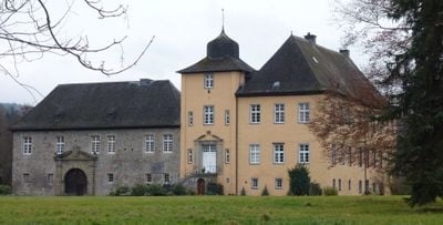
Haus Amecke, Medieval château in Sundern, Germany.
Haus Amecke is a manor house with medieval origins located in Sundern near Sorpesee lake. The building features traditional German architecture with stone walls and multiple wings, complemented by modern event spaces including a barn section with a large dance floor.
The manor house was established as the seat of the von Wrede-Amecke noble family, a prominent aristocratic lineage in the region. Over centuries, it evolved from a private residence to a venue serving the local community.
The Schloss-Scheune barn now serves as a venue for local weddings and community events throughout the year. Visitors can experience how the estate brings people together for celebrations while honoring its historic roots.
The estate can be accessed via Anliegerstraße and sits close to Sorpesee lake. Since the nearest public transportation stop is several kilometers away, having a car makes visiting more convenient.
The estate preserves a rare blend of medieval structures and modern event facilities with a full-sized dance floor housed within historical stone walls. This combination allows the place to showcase history while remaining practical for contemporary use.
Location: Sundern
GPS coordinates: 51.29690,7.94972
Latest update: December 9, 2025 12:25
St. Johannes
5.2 km
Leiden Christi
2.9 km
Saint Pancratius Church
2.5 km
Saint Anthony the Great Church
1.6 km
Im Sümpfel
975 m
Steinert
977 m
St. Johannes Baptist
5.2 km
Sundern
4.5 km
Feldgehölz westlich von Stockum
1.7 km
Naturdenkmal Ossenstein
4.7 km
Gräfenberg
3.8 km
Extensivgrünland südlich Hagen
5 km
Apfelhof Am Franziskus
4.7 km
Breloh
1.3 km
Nassweide südlich des großen Kamps
1.8 km
Langscheider Mark
4.8 km
St. Nikolaus
4.1 km
Tolmecke-Siepen
5 km
Eisteinberg
2.7 km
Magerweide Stockmecke
1.4 km
Halden südlich Bönkhausen
5.1 km
Krähetal östlich Grube Hermann
4.4 km
Bergbaurelikte Am Edlensteine
4.7 km
Ortsrandlagen Kernstadt Sundern
4.2 km
Südliche und östliche Ortsrandlagen von Hagen
4.5 km
Bönkhauser Bachtal und Eitmecke
4.7 km
LSG-Talraum der Kolmecke und der Kraehe suedwestlich von Allendorf einschliesslich einschliesslich angrenzender Gruenlandbereiche
2.3 km
Papenloh
2.8 kmVisited this place? Tap the stars to rate it and share your experience / photos with the community! Try now! You can cancel it anytime.
Discover hidden gems everywhere you go!
From secret cafés to breathtaking viewpoints, skip the crowded tourist spots and find places that match your style. Our app makes it easy with voice search, smart filtering, route optimization, and insider tips from travelers worldwide. Download now for the complete mobile experience.
A unique approach to discovering new places❞
— Le Figaro
All the places worth exploring❞
— France Info
A tailor-made excursion in just a few clicks❞
— 20 Minutes