Kälbersteine, Mountain summit in Bautzen District, Germany.
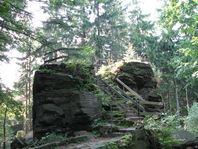
Kälbersteine is a mountain summit in the Lusatian Highlands that reaches 487 meters above sea level and features two striking granite blocks set within dense spruce forest. The rock outcrops rise approximately 205 meters above the surrounding valley, forming a natural focal point in the rolling landscape.
The mountain forms part of the Fernwanderweg Zittau-Wernigerode hiking route, which links multiple natural landmarks and creates historical connections across the Saxon landscape. This long-distance trail was developed to connect significant natural features throughout the region.
The mountain carries both a German name and an Upper Sorbian name, reflecting the linguistic heritage of the region's local communities.
The summit is accessible via a steep hiking path from a parking area located approximately 700 meters from the rock formations. Visitors should wear suitable footwear and allow adequate time, as the climb is steep and requires physical effort.
The granite blocks provide opportunities for traditional rock climbing and bouldering at various difficulty levels. For climbers, this is a locally known spot offering training possibilities in an open-air setting.
Location: Bautzen District
Elevation above the sea: 487 m
Part of: Lusatian Highlands
GPS coordinates: 51.07271,14.45299
Latest update: December 14, 2025 11:25
Evangelische Kirche Crostau
1.2 km
St. Mariä Himmelfahrt (Schirgiswalde)
1.6 km
Evangelische Kirche Schirgiswalde
1.7 km
Sohlander Castle
1.7 km
Friedhofskapelle St. Mariä Himmelfahrt
1.6 km
Nördlicher und östlicher Wirtschaftsflügel des Wirtschaftshofes (Einzeldenkmal zu ID-Nr. 09303914) Am Park 1
1.2 km
Katholische Pfarrkirche Mariä Himmelfahrt (Einzeldenkmal zu ID-Nr. 09252352) Kirchberg
1.6 km
Katholische Pfarrkirche Mariä Himmelfahrt und Kirchhof (Sachgesamtheit) Kirchberg (Ecke Sauerstraße)
1.7 km
Ecce-Homo-Statue am Aufgang zur Katholischen Pfarrkirche Kirchberg
1.6 km
Goetheschule Schirgiswalde
1.7 km
Ehemalige Papiermühle, heute Heimatmuseum, mit Brunnen im Hof Hauptstraße 11a
1.5 km
Schloss Crostau
1.2 km
Wohnhaus mit Ladeneinbau und daran anschließendes Altes Rathaus, in geschlossener Bebauung Markt 3
1.6 km
Niedergasse 16
1.4 km
Wohn- und Verwaltungsgebäude in offener Bebauung Hauptstraße 6
1.6 km
Wohnhaus Hauptstraße 5
1.6 km
Markt 1 Schirgiswalde
1.6 km
Rathaus Schirgiswalde
1.6 km
Marien-Apotheke Schirgiswalde
1.6 km
Niedermarkt 2a Schirgiswalde
1.6 km
Spreetalstraße 12
1.5 km
Markt 2 Schirgiswalde
1.6 km
Wohnhaus (Umgebinde) über winkligem Grundriss Wurbiser Straße 1
1.1 km
Kapplermühle
1.6 km
Wohnhaus in halboffener Bebauung Hauptstraße 1
1.6 km
Wohnhaus (Umgebinde) Kirchberg 2
1.6 km
Bildstock Niedermarkt (auf der Brücke Niedermarkt – Niedergasse)
1.5 km
Wohnhaus in halboffener Bebauung Hauptstraße 2
1.6 kmVisited this place? Tap the stars to rate it and share your experience / photos with the community! Try now! You can cancel it anytime.
Discover hidden gems everywhere you go!
From secret cafés to breathtaking viewpoints, skip the crowded tourist spots and find places that match your style. Our app makes it easy with voice search, smart filtering, route optimization, and insider tips from travelers worldwide. Download now for the complete mobile experience.
A unique approach to discovering new places❞
— Le Figaro
All the places worth exploring❞
— France Info
A tailor-made excursion in just a few clicks❞
— 20 Minutes