Landberg, Mountain summit in Tharandt, Germany
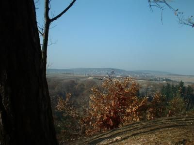
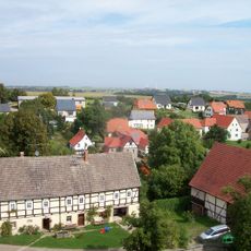
Landberg is a mountain summit reaching 426 meters within the Tharandt Forest, forming the northernmost point of the Erzgebirge range in Saxony. The slopes around the peak are forested and offer views over the woodland landscape and beyond on clear days.
The summit served local communities as a long-standing reference point and helped travelers navigate the Tharandt Forest. Its exposed location made it a familiar landmark for people moving through the region.
The summit is woven into local hiking culture, where visitors routinely undertake walks and explore the forest landscape. People use this place to experience the nature of the region and nurture their connection to this part of Saxony.
Several marked hiking trails lead to the summit, suited to different fitness levels. It is wise to bring proper hiking boots and weather protection, as conditions at elevation can change quickly.
The position of Landberg at the northern edge of the Erzgebirge creates a rare vantage point from which you can see both the mountainous terrain and the flatter areas of Saxony. On clear days, this perspective is particularly valuable for anyone wanting to grasp the geographic diversity of the region.
Location: Tharandt
Elevation above the sea: 426 m
Part of: Tharandt Forest
GPS coordinates: 50.99316,13.51080
Latest update: December 14, 2025 14:43
Kirche Fördergersdorf
2.3 km
Wassermühle Tharandt-Grillenburg
4.5 km
Burg Pohrsdorf
1.2 km
Kirche Herzogswalde
2.5 km
Spritzenhaus Pohrsdorf
1.3 km
Wohnstallhaus Buchenweg 7
3.6 km
Einzeldenkmale der Sachgesamtheit Dorfkirche und Kirchhof Mohorn: Kirche, Einfriedung, Kriegerdenkmal für die Gefallenen des Ersten Weltkrieges und zwei Grabmale (beides ehemalige Pfarrer, um 1700), siehe auch Sachgesamtheitsliste - Obj. 09304022 No
3.9 km
Brendelhof: Portal, Sandsteintrog und zwei Seitengebäude Kirchweg 2
1.1 km
Klippermühle Tharandt
4.4 km
Niedermühle Grund
2.7 km
Villa 1 Mountain Street
4.6 km
Sachgesamtheit Dorfkirche und Kirchhof Mohorn mit und folgenden Einzeldenkmalen: Kirche, Einfriedung, Kriegerdenkmal für die Gefallenen des Ersten Weltkrieges und zwei Grabmale (beides ehemalige Pfarrer, um 1700), siehe auch Einzeldenkmalliste - Obj
3.9 km
Leutholdmühle Helbigsdorf
4.6 km
Wohnstallhaus Landbergstraße 12
1.6 km
Wohnhaus Freiberger Straße 24
4.6 km
Pfarrhof Pfarrgasse 2
2.3 km
Schmalspurbahn Freital-Potschappel– Nossen Mohorn
4 km
Schulgebäude mit drei Baukörpern Friedrich-Schiller-Straße 21
2.6 km
Obermühle Grund
2.7 km
Häuslerhaus (ehemaliges Huthaus) Am Tharandter Wald 54
2.3 km
Spritzenhaus mit intakter Spritze Pohrsdorf
1.3 km
Wegestein Fördergersdorf
2.2 km
Grillenburger Mühle; Wiesenhaus Hauptstraße 18
4.5 km
Grenzstein Mühlweg 2 (gegenüber)
1.7 km
Wohnhaus Landbergstraße 16
1.5 km
Villa Am Hartheberg 11
2.6 km
Jagdschloss und Gedenkstein sowie Parkanlage Hauptstraße 13
2.7 km
Kirche, Kirchhof und Einfriedungsmauer mit Treppenanlage, Kriegerdenkmal für die Gefallenen des Ersten Weltkrieges, neun alten Grabmalen und Grabplatte Am Bach -
2.5 kmVisited this place? Tap the stars to rate it and share your experience / photos with the community! Try now! You can cancel it anytime.
Discover hidden gems everywhere you go!
From secret cafés to breathtaking viewpoints, skip the crowded tourist spots and find places that match your style. Our app makes it easy with voice search, smart filtering, route optimization, and insider tips from travelers worldwide. Download now for the complete mobile experience.
A unique approach to discovering new places❞
— Le Figaro
All the places worth exploring❞
— France Info
A tailor-made excursion in just a few clicks❞
— 20 Minutes