Mordloch, Cave system in Baden-Württemberg, Germany.
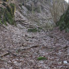
Mordloch is a cave system in the limestone of the Swabian Jura with tunnels, chambers, and underground lakes that extend deep underground. The public walking section covers only the entrance portion, while the full passages continue much deeper into the mountain.
The cave has been explored over many decades, but a major incident in 1977 brought it into public focus. This event led to changes in how people understood the dangers and safety needs within such cave systems.
The name comes from a local legend about someone who hid a secret in these caves long ago, and the story became part of how people in the region understood this place. Such tales shaped how visitors and locals think about caves in the Swabian landscape.
Waterproof shoes and a good light source are essential, as the passages can be slippery and lighting helps you see the formations and navigate safely. Keep in mind that heavy rainfall causes water levels to rise quickly, which can make parts of the cave inaccessible.
Deep inside the cave is a large chamber called Gammahalle that rises vertically through several layers of limestone. This chamber reveals how different rock layers formed over long periods and tells the geological story of the area.
Location: Baden-Württemberg
Fee: No
GPS coordinates: 48.66423,9.89406
Latest update: December 9, 2025 18:42
Burg Ravenstein
969 m
Fernmeldeturm Schnittlingen
2.1 km
Burg Roggenstein
1.6 km
Eybacher Hütte
1.4 km
St. Johannes
1.7 km
1 Linde am Berg nördl.Stötten
2.5 km
1 Linde am Hackmesser
2 km
1 Linde, Fleischling
2.3 km
Lindenreihe am Hackmesser
1.8 km
Doline mit Linde oberhalb Stötten
2 km
2 Ulmen, 4 Linden
2.1 km
1 Linde am Ravensteiner Weg
1.1 km
2 Teiche südwestl.Steinenkirch (Frohnhofhülben)
778 m
Hülbe nördl. Stötten "Reutehülbe"
2.1 km
Doline mit Linde oberhalb Stötten
2 km
2 Linden beim Schulhaus
2.4 km
3 Linden beim Lindenhof "Banzerlinde"
2.1 km
3 Linden in Steinenkirch bei der Kirche
1.3 km
4 Linden östl.Steinenkirch
1.9 km
1 Ulme am Sinnwang
907 m
Berghülbe
1.7 km
1 Bergahorn,1 Vogelbeere,1 Mehlbeere a.Pfergelst.
2.1 km
Hülbe in der Ibene östl.von Steinenkirch
2.4 km
12 Linden bei Stötten "Stöttener Linden"
2.2 km
1 Linde am Sinnwang
902 m
Sonnenuhr
2.2 km
Wayside cross
2.3 km
Wayside cross
2 kmVisited this place? Tap the stars to rate it and share your experience / photos with the community! Try now! You can cancel it anytime.
Discover hidden gems everywhere you go!
From secret cafés to breathtaking viewpoints, skip the crowded tourist spots and find places that match your style. Our app makes it easy with voice search, smart filtering, route optimization, and insider tips from travelers worldwide. Download now for the complete mobile experience.
A unique approach to discovering new places❞
— Le Figaro
All the places worth exploring❞
— France Info
A tailor-made excursion in just a few clicks❞
— 20 Minutes