Enable Location

We need your location to show you interesting places around you

Discover nearby places

Find interesting locations and hidden gems around you

Precise directions

Get accurate directions and distances to places

Your location is never shared with other users. It's only used when you tap the location button.

Spellenstein

Log in to your account

Start exploring — it's free

Trusted by 63,670 travelers worldwide

Continue with Google
Continue with Apple
or

We will send you a code to connect

By continuing, you accept our Terms and Conditions and our Privacy Policy

Check your inbox

We've sent a pincode in your inbox. Please enter the code below.

Discussion Reviews 1 Photos
3.7k Popularity

Spellenstein, Neolithic menhir in Rentrisch, Germany

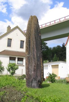
The Spellenstein is an upright sandstone block in Sankt Ingbert that rises about 6.55 meters (21.5 feet) above ground level. Its foundation extends roughly 1.5 meters (5 feet) below the surface, and the stone weighs between 15 and 20 tons.

The stone was originally erected during the Neolithic period and later served as a boundary marker in medieval times. Excavations in 1894 exposed the foundation and uncovered a time capsule from a 1935 survey.

The sandstone block marked territorial boundaries along a medieval trade route that eventually became the Kaiserstraße. Visitors can today trace this connection to the historical path network.

The stone now stands in a residential front yard where it is protected by a fence while remaining visible to passersby. You can view it from the street, but should respect the private setting.

Geographer Tilemann Stella recorded the stone in his 1564 regional survey and marked it with a special boundary stone symbol on his maps. This makes it one of the earliest documented megaliths in the region's cartography.

The community of curious travelers

AroundUs brings together thousands of curated places, local tips, and hidden gems, enriched daily by 60,000 contributors worldwide.

Start exploring
Location
Height
6.55 m
Address
Am Spellenstein
GPS coordinates
49.26747,7.08467
Latest update
December 11, 2025 18:09
Reviews
Share your experience

No review yet

Discussions
Start a discussion...

No discussion yet

« Spellenstein - Neolithic menhir in Rentrisch, Germany » is provided by Around Us (aroundus.com). Images and texts are derived from Wikimedia project under a Creative Commons license. You are allowed to copy, distribute, and modify copies of this page, under the conditions set by the license, as long as this note is clearly visible.

Discover hidden gems everywhere you go!

From secret cafés to breathtaking viewpoints, skip the crowded tourist spots and find places that match your style. Our app makes it easy with voice search, smart filtering, route optimization, and insider tips from travelers worldwide. Download now for the complete mobile experience.

Around Us App Screenshot

A unique approach to discovering new places

Le Figaro

All the places worth exploring

France Info

A tailor-made excursion in just a few clicks

20 Minutes

Around Us
Travel Guide & Maps
Download

Send to your phone

QR Code
1

Open the camera app on your mobile.

2

Point at the QR code with your camera. A notification will appear.

3

Tap the notification to open the link.