Talsperre Lehnmühle, Cultural heritage reservoir in Dippoldiswalde and Hartmannsdorf-Reichenau, Germany.
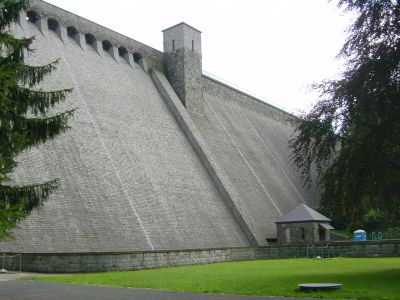
The Lehnmühle Dam is a concrete barrier between Dippoldiswalde and Hartmannsdorf-Reichenau that holds back water to protect the region from flooding and supply water to local communities. The structure creates a large lake bordered by forested areas and accessible footpaths along the shore.
This dam was built in 1927 as part of early 20th-century efforts to improve water management and flood prevention in eastern Saxony. The project reflected the engineering methods and priorities of that era.
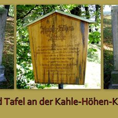
The name comes from an old mill that once operated at this location, powered by flowing water. Today, visitors can experience how this site connects the region's milling past with its present role in water management.
The site is accessible by car with parking available near the dam, and walking trails circle the reservoir at varying difficulty levels. Visit during dry weather to make the trails easier to navigate safely.
The entire structure was built from reinforced concrete, a relatively new technique in the 1920s that showcased cutting-edge engineering for its era. This construction method made the dam a notable example of industrial innovation from that period.
Location: Dippoldiswalde
Location: Hartmannsdorf-Reichenau
Inception: 1927
Elevation above the sea: 522 m
Address: Hartmannsdorf
GPS coordinates: 50.83533,13.59060
Latest update: December 8, 2025 21:01
Frauenstein Castle
5 km
Schloss Frauenstein
5.1 km
Schloss Naundorf
4.6 km
Kahlehöhenkirche
2 km
Frauenstein Castle
5.1 km
St.-Gallus-Kirche (Sadisdorf)
3.3 km
Katharinenkirche
2.6 km
Körnermühle Ammelsdorf
4.1 km
Schule Markt 3
5.2 km
Lehnmühle Hennersdorf
355 m
Laurentiuskirche
2.3 km
'''Schloss Naundorf''' (Einzeldenkmal zu ID-Nr. 09278033) Schlossberg 1; 1g
4.7 km
Überdachter Brunnen mit Handschwengelpumpe Wassergasse 10 (bei)
5.1 km
Windmühle Reichstädt
1.9 km
Kahlehöhen-Kirche
2 km
Aussichtsturm - -
4.7 km
Sachgesamtheit Burgruine und Neues Schloss Frauenstein, bestehend aus den Einzeldenkmalen: Schloss (heute Museum – siehe auch Am Schloß 2, 3 - Obj. 09206524), Burgruine mit Ringmauer (siehe auch Am Schloß (ohne HNr.) - Obj. 09206525), Torhaus mit
5 km
Wohnhaus in geschlossener Bebauung Markt 30
5.2 km
Einzeldenkmale der Sachgesamtheit Burgruine und Neues Schloss Frauenstein: Burgruine mit Nordturm, Südturm, Ringmauer, Palas und Innerer Mauer (siehe auch Sachgesamtheitsliste - Obj. 09300469, Am Schloß 1, 2, 3) Am Schloß -
5 km
Ehemalige Schmiede Frauensteiner Straße 14b
3.3 km
Wegestein - -
2.5 km
Röthenbacher Mühle Weißeritzstraße 1
2.7 km
Silbermannbrunnen
5.2 km
Lehngut (ehemals Wohnstallhaus) Untere Dorfstraße 70
1.5 km
Zwei Wegesteine Röthenbacher Straße -
3.4 km
Ottos Eck
4.7 km
Markt 4 (Frauenstein)
5.2 km
Wohnstallhaus und Scheune eines ehemaligen Kleinbauernhofes (Geburtshaus von Gottfried und Andreas Silbermann) Freitaler Straße 4
4.2 kmVisited this place? Tap the stars to rate it and share your experience / photos with the community! Try now! You can cancel it anytime.
Discover hidden gems everywhere you go!
From secret cafés to breathtaking viewpoints, skip the crowded tourist spots and find places that match your style. Our app makes it easy with voice search, smart filtering, route optimization, and insider tips from travelers worldwide. Download now for the complete mobile experience.
A unique approach to discovering new places❞
— Le Figaro
All the places worth exploring❞
— France Info
A tailor-made excursion in just a few clicks❞
— 20 Minutes