Talsperre Malter, Reservoir and cultural monument in Dippoldiswalde, Germany
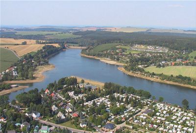
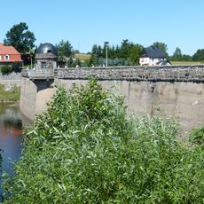
Talsperre Malter is a reservoir with a curved gravity dam made of quarry stone masonry, featuring a crown length of 193 meters and width of 6.1 meters. The structure was built with a storage capacity of 8.78 million cubic meters and collects water from the Rote Weißeritz stream.
Construction of the reservoir took place between 1908 and 1913, prompted by severe flooding in 1897 that demonstrated the urgent need for water regulation in the region. That flood made clear to authorities and residents alike how essential it was to control future overflow.
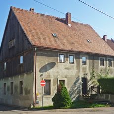
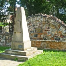
The reservoir is tied to local history through the relocation of Niedermalter village, which fundamentally reshaped the landscape when it was built. The water surface now defines the regional scenery and reflects how infrastructure permanently transformed life in the area.
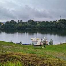
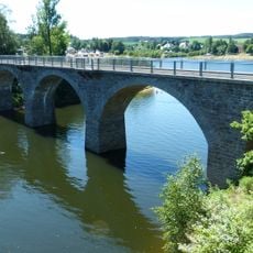
The reservoir can be visited from paths around the water that offer different perspectives of the structure. Visitors should wear sturdy footwear and follow local walking routes for the best experience.
From 1968 to 1983, an underwater station called Malter I operated at the reservoir, conducting research in underwater biology. This unusual project was an early example of scientific work in extreme environments.
Location: Dippoldiswalde
Elevation above the sea: 332 m
Phone: +4935143878490
GPS coordinates: 50.92190,13.65310
Latest update: December 8, 2025 19:40
Altarstein
1.7 km
Strandbad Malter
169 m
Malter railway bridge
274 m
Sühnestein Malterweg
1.1 km
Findlingskreuz
1.4 km
Wegestein Malterweg
1.1 km
Wohnhaus auf Hakengrundriss Bergstraße 89
1.5 km
König-Johann-Turm Hohe Straße -
2 km
Wohnhaus Bergstraße 79
1.5 km
Wohnhaus mit Anklängen an Schweizerstil Bergstraße 136
1.3 km
Wohnstallhaus mit integriertem Wirtschaftsteil Talsperrenstraße 11
2.3 km
Kriegerdenkmal für die Gefallenen des Ersten Weltkrieges Berreuther Straße -
2.4 km
Wohnhaus in offener Bebauung Bergstraße 134–135
1.3 km
Bildstock mit Kreuzigungsrelief Thomas-Müntzer-Straße -
667 m
Heisterbergk-Denkmal Bahnhofstraße – (jetzt Dr.-Friedrichs-Str.)
2.6 km
Wohnstallhaus Bergstraße 82
1.5 km
Wohnhaus Große Mühlstraße 28
2.6 km
Steinerner Tisch mit steinernen Sitzbänken - -
2 km
Tatarengrab in Dippoldiswalde
2.2 km
Bildstock Thomas-Müntzer-Straße -
1.2 km
Wegestein Große Mühlstraße -
2.7 km
'''Staumauer, Schieberschacht und Gebäude''' (Einzeldenkmal zu ID-Nr. 09303658) Am Stausee 1; 6
667 m
Zwei Gedenksteine Große Mühlstraße -
2.6 km
Dreiflügelbau, heute Altenpflegeheim Bergstraße 137
1.3 km
Doppelwohnhaus der AWG, davor zeitgenössische Laterne Goethestraße 11; 13
2.4 km
Gedenkstein - -
955 m
Wohnstallhaus Thomas-Müntzer-Straße 17
964 m
Wegestein Talsperrenstraße -
2.4 kmVisited this place? Tap the stars to rate it and share your experience / photos with the community! Try now! You can cancel it anytime.
Discover hidden gems everywhere you go!
From secret cafés to breathtaking viewpoints, skip the crowded tourist spots and find places that match your style. Our app makes it easy with voice search, smart filtering, route optimization, and insider tips from travelers worldwide. Download now for the complete mobile experience.
A unique approach to discovering new places❞
— Le Figaro
All the places worth exploring❞
— France Info
A tailor-made excursion in just a few clicks❞
— 20 Minutes