Enable Location

We need your location to show you interesting places around you

Discover nearby places

Find interesting locations and hidden gems around you

Precise directions

Get accurate directions and distances to places

Your location is never shared with other users. It's only used when you tap the location button.

Stausee Sohland

Log in to your account

Start exploring — it's free

Trusted by 61,571 travelers worldwide

Continue with Google
Continue with Apple
or

We will send you a code to connect

By continuing, you accept our Terms and Conditions and our Privacy Policy

Check your inbox

We've sent a pincode in your inbox. Please enter the code below.

Stausee Sohland

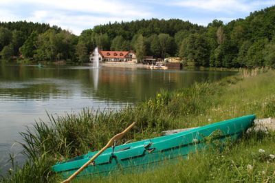
Stausee Sohland, reservoir in Germany

Description

Stausee Sohland is a reservoir on the Spree River in Sohland an der Spree, Saxony. The water body was created by damming the river and forms a significant expanse surrounded by forested banks and accessible shoreline.

History

The reservoir was constructed in the mid-20th century to store water for power generation and flood control. Its creation reshaped the river valley and established a new aquatic environment in the region.

Practical

The reservoir is accessible via walking paths and cycling routes that run along its shorelines. Multiple entry points allow visitors to access the water and surrounding areas for outdoor activities.

Did you know?

The water body attracts anglers seeking several fish species found in its waters. The shoreline sections provide seasonal habitats for birdwatching and wildlife observation throughout the year.

Shares border with
Altscheidenbach
GPS coordinates
51.06000,14.43528
Latest update
December 15, 2025 13:27

AroundUs brings together thousands of curated places, local tips, and hidden gems, enriched daily by 60,000 contributors worldwide. Discover all places nearby (Sohland an der Spree).

Around this place
Kälbersteine
Germany

Kälbersteine

1.9 km
Sohland/Spree observatory
Germany

Sohland/Spree observatory

1.9 km
Roter Hof
Germany

Roter Hof

1.5 km
Himmelsbrücke
Germany

Himmelsbrücke

1.1 km
Sohlander Castle
Germany

Sohlander Castle

461 m
Kleine Aufbahrungshalle (Einzeldenkmal zu ID-Nr. 09300890) Am Kirchberg
Germany

Kleine Aufbahrungshalle (Einzeldenkmal zu ID-Nr. 09300890) Am Kirchberg

1.6 km
Gerhart-Hauptmann-Schule mit Sonnenuhr Gerhart-Hauptmann-Straße 4
Germany

Gerhart-Hauptmann-Schule mit Sonnenuhr Gerhart-Hauptmann-Straße 4

1.3 km
Treppenanlage zum Eingangsbereich des Kirchhofs (Einzeldenkmal zu ID-Nr. 09300890) Am Kirchberg
Germany

Treppenanlage zum Eingangsbereich des Kirchhofs (Einzeldenkmal zu ID-Nr. 09300890) Am Kirchberg

1.7 km
Ehemalige Papiermühle, heute Heimatmuseum, mit Brunnen im Hof Hauptstraße 11a
Germany

Ehemalige Papiermühle, heute Heimatmuseum, mit Brunnen im Hof Hauptstraße 11a

1.8 km
Schloss und Park des ehemaligen Rittergutes (Roter Hof (Sohland an der Spree)) Straße am Friedenshain 20
Germany

Schloss und Park des ehemaligen Rittergutes (Roter Hof (Sohland an der Spree)) Straße am Friedenshain 20

1.5 km
Villa Sonneneck, Villengarten mit Einfriedung und Gartenpavillon Schluckenauer Straße 14
Germany

Villa Sonneneck, Villengarten mit Einfriedung und Gartenpavillon Schluckenauer Straße 14

2.2 km
Kirche und Kirchhof Sohland (Sachgesamtheit) Am Kirchberg
Germany

Kirche und Kirchhof Sohland (Sachgesamtheit) Am Kirchberg

1.6 km
Saalkirche (Einzeldenkmal zu ID-Nr. 09300890) Am Kirchberg
Germany

Saalkirche (Einzeldenkmal zu ID-Nr. 09300890) Am Kirchberg

1.6 km
Royal Saxon milestone Pilzdörfel
Germany

Royal Saxon milestone Pilzdörfel

1.6 km
Gasthof Zum Erbgericht Am Markt 16
Germany

Gasthof Zum Erbgericht Am Markt 16

1.7 km
Rathaus Schirgiswalde
Germany

Rathaus Schirgiswalde

1.9 km
Gasthaus Stiebitz mit Umgebinde-Anbau Am Markt 11
Germany

Gasthaus Stiebitz mit Umgebinde-Anbau Am Markt 11

1.8 km
Wohn- und Verwaltungsgebäude in offener Bebauung Hauptstraße 6
Germany

Wohn- und Verwaltungsgebäude in offener Bebauung Hauptstraße 6

1.9 km
Wohnhaus Hauptstraße 5
Germany

Wohnhaus Hauptstraße 5

1.9 km
Wohnhaus (Umgebinde) im Hakengrundriss Zittauer Straße 44
Germany

Wohnhaus (Umgebinde) im Hakengrundriss Zittauer Straße 44

934 m
Bautzener Straße 4
Germany

Bautzener Straße 4

553 m
Royal Saxon milestone Sohland
Germany

Royal Saxon milestone Sohland

1.7 km
Hauptstraße 30
Germany

Hauptstraße 30

2.1 km
Petersbach 2
Germany

Petersbach 2

469 m
Marien-Apotheke Schirgiswalde
Germany

Marien-Apotheke Schirgiswalde

1.7 km
Kapplermühle
Germany

Kapplermühle

1.2 km
Gasthof „Petersbach“ (Umgebinde) Sohlander Straße 69
Germany

Gasthof „Petersbach“ (Umgebinde) Sohlander Straße 69

419 m
Empfangsgebäude des Bahnhofs Bahnhofstraße 45
Germany

Empfangsgebäude des Bahnhofs Bahnhofstraße 45

709 m
Show the full map
« Stausee Sohland - reservoir in Germany » is provided by Around Us (aroundus.com). Images and texts are derived from Wikimedia project under a Creative Commons license. You are allowed to copy, distribute, and modify copies of this page, under the conditions set by the license, as long as this note is clearly visible.

Discover hidden gems everywhere you go!

From secret cafés to breathtaking viewpoints, skip the crowded tourist spots and find places that match your style. Our app makes it easy with voice search, smart filtering, route optimization, and insider tips from travelers worldwide. Download now for the complete mobile experience.

Around Us App Screenshot

A unique approach to discovering new places

Le Figaro

All the places worth exploring

France Info

A tailor-made excursion in just a few clicks

20 Minutes

Around Us
Travel Guide & Maps
Download

Send to your phone

QR Code
1

Open the camera app on your mobile.

2

Point at the QR code with your camera. A notification will appear.

3

Tap the notification to open the link.