Stadel, satteldachbau mit Riegelbundwerk, 17./18. Jahrhundert
Location: Bodenkirchen
Address: Erdmannsdorfer Straße 32
GPS coordinates: 48.39660,12.39344
Latest update: November 24, 2023 20:01
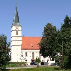
St. Johannes der Täufer
1.5 km
Cultural heritage D-2-7540-0015 in Bodenkirchen
1.5 km
Mariä Himmelfahrt
894 m
Schloss Bonbruck
933 m
Hauskapelle
1.4 km
Katholische Kapelle Maria
1.3 km
Cultural heritage D-2-7540-0016 in Bodenkirchen
929 m
Scheune Ensbach 1 in Bodenkirchen
1.7 km
Cultural heritage D-2-7640-0006 in Bodenkirchen
1.5 km
Kornspeicher Ensbach 1 in Bodenkirchen
1.6 km
Stadel und Getreidekasten eines Vierseithofs mit Windrad
2 km
Stadel eines Dreiseithofs
2 km
Cultural heritage D-2-7540-0125 in Bodenkirchen
885 m
Kornspeicher Ensbach 1 in Bodenkirchen
1.6 km
Windrad Nähe Dorfstraße in Bodenkirchen
2 km
Ehemaliges Kleinbauernhaus
1.5 km
Stadel
1.9 km
Vierseithof mit Stadel
1.6 km
Zugehöriger schmaler Stadel
173 m
Wayside cross
1.6 km
Kriegerdenkmal Bonbruck
919 m
Wayside cross
1.7 km
Wayside cross
1.7 km
Wayside cross
1.8 km
Wayside cross
1.9 km
Catholic church building, wayside cross, Christianity
396 m
Wayside cross
682 m
Wayside cross
823 mReviews
Visited this place? Tap the stars to rate it and share your experience / photos with the community! Try now! You can cancel it anytime.
Discover hidden gems everywhere you go!
From secret cafés to breathtaking viewpoints, skip the crowded tourist spots and find places that match your style. Our app makes it easy with voice search, smart filtering, route optimization, and insider tips from travelers worldwide. Download now for the complete mobile experience.

A unique approach to discovering new places❞
— Le Figaro
All the places worth exploring❞
— France Info
A tailor-made excursion in just a few clicks❞
— 20 Minutes