Chest opened
+${chestReward.xp} XP
Explorer
NOUVEAU ×${chestReward.collectible.quantity}
tapez pour fermer
Chest locked

Open chests in the app

Around Us is built for your phone — chests unlock when you walk, explore and capture nearby places.

Enable Location

We need your location to show you interesting places around you

Discover nearby places

Find interesting locations and hidden gems around you

Precise directions

Get accurate directions and distances to places

Your location is never shared with other users. It's only used when you tap the location button.

Saint-Gouéno

Log in to your account

Start exploring — it's free

Trusted by 72,883 travelers worldwide

Continue with Google
Continue with Apple
or

We will send you a code to connect

By continuing, you accept our Terms and Conditions and our Privacy Policy

Check your inbox

We've sent a pincode in your inbox. Please enter the code below.

Discussion Reviews 1 Photos
2.6k Popularity

Saint-Gouéno, Delegated commune in canton of Collinée, Côtes-d'Armor, France.

Saint-Gouéno was a small rural commune located in the Côtes-d'Armor department of Brittany, covering approximately 20 square kilometers with elevations ranging from 149 to 313 meters above sea level.

The historic commune of Saint-Gouéno ceased to exist as an independent administrative entity in 2016 when it merged with other communes to form the new commune of Le Mené.

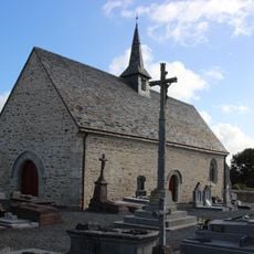
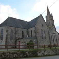
The village maintained local Breton traditions with its church dedicated to Saint Goueznou and organized community events that strengthened social bonds among residents known as Gouénovais.

Saint-Gouéno was accessible via departmental roads and had its town hall located at 10 place de l'Église, with postal code 22330 and INSEE code 22297.

The commune had the distinctive feature of maintaining steady demographic growth from 640 inhabitants in 1999 to 658 in 2009 despite its modest size and rural character.

The community of curious travelers

AroundUs brings together thousands of curated places, local tips, and hidden gems, enriched daily by 60,000 contributors worldwide.

Start exploring
Location
Elevation above the sea
313 m
Shares border with
Le Mené, Plessala, Saint-Gilles-du-Mené, Saint-Glen, Saint-Jacut-du-Mené, Trébry
Address
Saint-Gouéno, 22330 Le Mené, France
GPS coordinates
48.26750,-2.56861
Latest update
August 25, 2025 13:36
Reviews
Share your experience

No review yet

Discussions
Start a discussion...

No discussion yet

« Saint-Gouéno - Delegated commune in canton of Collinée, Côtes-d'Armor, France » is provided by Around Us (aroundus.com). Images and texts are derived from Wikimedia project under a Creative Commons license. You are allowed to copy, distribute, and modify copies of this page, under the conditions set by the license, as long as this note is clearly visible.

Discover hidden gems everywhere you go!

From secret cafés to breathtaking viewpoints, skip the crowded tourist spots and find places that match your style. Our app makes it easy with voice search, smart filtering, route optimization, and insider tips from travelers worldwide. Download now for the complete mobile experience.

Around Us App Screenshot

A unique approach to discovering new places

Le Figaro

All the places worth exploring

France Info

A tailor-made excursion in just a few clicks

20 Minutes

Around Us
Travel Guide & Maps
Download

Send to your phone

QR Code
1

Open the camera app on your mobile.

2

Point at the QR code with your camera. A notification will appear.

3

Tap the notification to open the link.