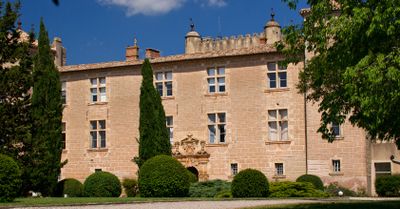
Château de Cambous, Medieval castle in Viols-en-Laval, France
Château de Cambous is a medieval castle featuring a quadrangular layout with three rectangular towers and multi-story windows with muntins across its facades. The structure creates a cohesive architectural composition typical of its period.
The castle was first documented in 1504, followed by major building phases during the 16th and 17th centuries. Further renovations took place in the 18th century as the property adapted to changing needs.
The main entrance displays ornate details with pilasters depicting chained wolves and an inscription evoking stars and the sun. These symbols reflect the values that its owners once held dear.
Access to the courtyard and arcades is straightforward, though the site functions today as a residential property with modern adaptations. Visit during cooler months to enjoy exploring at a relaxed pace without summer crowds.
The Renaissance courtyard preserves original arcades and an ancient well within the castle's quadrangular structure. These elements reveal the everyday infrastructure that residents relied on centuries ago.
Location: Viols-en-Laval
GPS coordinates: 43.75420,3.72556
Latest update: December 9, 2025 12:24
Pic Saint-Loup
7.4 km
Château de Montferrand
9.5 km
Prehistoric village of Cambous
594 m
Château de la Roquette
8.7 km
Église Saint-Martin de Saint-Martin-de-Londres
4.2 km
Dolmen de la Draille
1.5 km
Église de la Nativité-de-Saint-Jean-Baptiste de Saint-Jean-de-Cuculles
8.8 km
Dolmens of Cazarils
1.4 km
Église Saint-Étienne d'Argelliers
7.6 km
Boscorre Dolmen
8.3 km
Ô Vent d'Ange
4.6 km
Église Saint-Gilles de Saint-Gély-du-Fesc
9.3 km
Église Saint-Gérard de Mas-de-Londres
3.8 km
Église Saint-Blaise de Combaillaux
9.2 km
Dolmen de la Carrière de l'Espinasse
8.8 km
Église de l'Invention-de-Saint-Étienne de Viols-le-Fort
2.2 km
Puechabon
9.4 km
Église Notre-Dame-de-l'Assomption des Matelles
7.3 km
Église de l'Invention-de-Saint-Étienne de Cazevieille
5.3 km
Chapelle Saint-Joseph de Pic Saint-Loup
7.4 km
Église Saint-Pierre-aux-Liens de Puéchabon
9.8 km
Source du Lirou
6.8 km
Boussargues (Argelliers, Hérault): Un habitat ceinturé chalcolithique: Les fouilles du secteur ouest. Albert Colomer, Jacques Coularou, and Xavier Gutherz. Documents d'Archéologie Française No. 24. Editions de la Maison des Sciences de L'Homme, P
3.6 km
Grotte du Suquet
5.6 km
Roc de Pampelune
6.3 km
Grand Juyan de Roubiac
5 km
Chapelle du couvent de Notre-Dame des Champs
8.1 km
Immeuble, place de l'Église
4.2 kmVisited this place? Tap the stars to rate it and share your experience / photos with the community! Try now! You can cancel it anytime.
Discover hidden gems everywhere you go!
From secret cafés to breathtaking viewpoints, skip the crowded tourist spots and find places that match your style. Our app makes it easy with voice search, smart filtering, route optimization, and insider tips from travelers worldwide. Download now for the complete mobile experience.
A unique approach to discovering new places❞
— Le Figaro
All the places worth exploring❞
— France Info
A tailor-made excursion in just a few clicks❞
— 20 Minutes