Enable Location

We need your location to show you interesting places around you

Discover nearby places

Find interesting locations and hidden gems around you

Precise directions

Get accurate directions and distances to places

Your location is never shared with other users. It's only used when you tap the location button.

Col du Mont de Fourche

Log in to your account

Start exploring — it's free

Trusted by 62,531 travelers worldwide

Continue with Google
Continue with Apple
or

We will send you a code to connect

By continuing, you accept our Terms and Conditions and our Privacy Policy

Check your inbox

We've sent a pincode in your inbox. Please enter the code below.

Col du Mont de Fourche

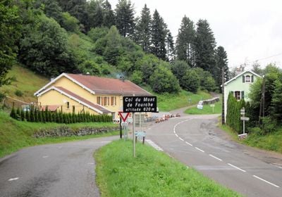
Col du Mont de Fourche, Mountain pass in Vosges, France

Col du Mont de Fourche is a mountain pass in the Vosges at roughly 620 meters elevation, accessible via several routes from Faucogney, Rupt-sur-Moselle, and Saulx. The climb spans nearly 4 kilometers with gradients varying between 5 and 9 percent, with the final kilometer being the steepest section.

The pass has grown into a cycling destination over decades through steady local riding activities in the Vosges. This organic development has made it a recognized goal for cyclists across the wider region.

The surrounding villages are deeply connected to cycling, with locals regularly using the route for training and recreational rides. The place has naturally become a gathering point for cycling enthusiasts from across the region.

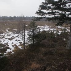
Visitors should plan different amounts of time depending on which route they choose, as multiple ascent options vary in difficulty. The pass is walkable year-round, but conditions change with the seasons, particularly during winter snowfall.

The ascent alternates regularly between gentler and steeper sections, offering varied physical demands rather than constant gradient. This variation makes each segment of the climb feel physically distinct.

The community of curious travelers

AroundUs brings together thousands of curated places, local tips, and hidden gems, enriched daily by 60,000 contributors worldwide.

Start exploring
Location
Location
Location
Elevation above the sea
620 m
GPS coordinates
47.90417,6.64524
Latest update
December 14, 2025 17:44
Around this place
Copper mine at Le Thillot
France

Copper mine at Le Thillot

9.3 km
Prieuré d'Hérival
France

Prieuré d'Hérival

9.7 km
Cascade du Géhard
France

Cascade du Géhard

9 km
Copper mine at Le Thillot
France

Copper mine at Le Thillot

9.3 km
Réserve naturelle régionale de la tourbière des Charmes
France

Réserve naturelle régionale de la tourbière des Charmes

7.4 km
Musée départemental de la montagne
France

Musée départemental de la montagne

9.9 km
Église Saint-Georges de Faucogney-et-la-Mer
France

Église Saint-Georges de Faucogney-et-la-Mer

9 km
Fontaine de Faucogney-et-la-Mer
France

Fontaine de Faucogney-et-la-Mer

9.1 km
Croix monumentale du Mont-Dahin
France

Croix monumentale du Mont-Dahin

8.1 km
Croix des morts de Faucogney-et-la-Mer
France

Croix des morts de Faucogney-et-la-Mer

9.2 km
Enceinte de Faucogney-et-la-Mer
France

Enceinte de Faucogney-et-la-Mer

9.2 km
Grenier chalot de Saint-Bresson
France

Grenier chalot de Saint-Bresson

9.8 km
Croix monumentale de La Longine
France

Croix monumentale de La Longine

4.7 km
Église Saint-Laurent de Beulotte-Saint-Laurent
France

Église Saint-Laurent de Beulotte-Saint-Laurent

5.4 km
Église Saint-Vincent-de-Paul de Ferdrupt
France

Église Saint-Vincent-de-Paul de Ferdrupt

4.8 km
Église Notre-Dame-de-l'Assomption de Château-Lambert
France

Église Notre-Dame-de-l'Assomption de Château-Lambert

9.8 km
Église Saint-Louis de Vecoux
France

Église Saint-Louis de Vecoux

8.4 km
Église Saint-Antoine de Thiéfosse
France

Église Saint-Antoine de Thiéfosse

9.8 km
Église Saint-Jean-Baptiste du Thillot
France

Église Saint-Jean-Baptiste du Thillot

9.5 km
Église de l'Assomption-de-la-Vierge de Haut-du-Them-Château-Lambert
France

Église de l'Assomption-de-la-Vierge de Haut-du-Them-Château-Lambert

8.9 km
Église Saints-Remy-et-Blaise de Ramonchamp
France

Église Saints-Remy-et-Blaise de Ramonchamp

7.2 km
Église de l'Immaculée-Conception de Girmont-Val-d'Ajol
France

Église de l'Immaculée-Conception de Girmont-Val-d'Ajol

8.6 km
Église Notre-Dame-de-l'Assomption de Servance
France

Église Notre-Dame-de-l'Assomption de Servance

10.1 km
Église de la Nativité-de-Saint-Jean-Baptiste de Corravillers
France

Église de la Nativité-de-Saint-Jean-Baptiste de Corravillers

2.2 km
Église Saint-Étienne de Rupt-sur-Moselle
France

Église Saint-Étienne de Rupt-sur-Moselle

2.9 km
Orgue de tribune de l'église Saint-Georges de Faucogney-et-la-Mer
France

Orgue de tribune de l'église Saint-Georges de Faucogney-et-la-Mer

9 km
Chapelle Saint-Roch de Maxonchamp
France

Chapelle Saint-Roch de Maxonchamp

4.8 km
Chapelle Notre-Dame dite chapelle de Beauregard de La Montagne
France

Chapelle Notre-Dame dite chapelle de Beauregard de La Montagne

5 km
Show the full map
« Col du Mont de Fourche - Mountain pass in Vosges, France » is provided by Around Us (aroundus.com). Images and texts are derived from Wikimedia project under a Creative Commons license. You are allowed to copy, distribute, and modify copies of this page, under the conditions set by the license, as long as this note is clearly visible.

Discover hidden gems everywhere you go!

From secret cafés to breathtaking viewpoints, skip the crowded tourist spots and find places that match your style. Our app makes it easy with voice search, smart filtering, route optimization, and insider tips from travelers worldwide. Download now for the complete mobile experience.

Around Us App Screenshot

A unique approach to discovering new places

Le Figaro

All the places worth exploring

France Info

A tailor-made excursion in just a few clicks

20 Minutes

Around Us
Travel Guide & Maps
Download

Send to your phone

QR Code
1

Open the camera app on your mobile.

2

Point at the QR code with your camera. A notification will appear.

3

Tap the notification to open the link.