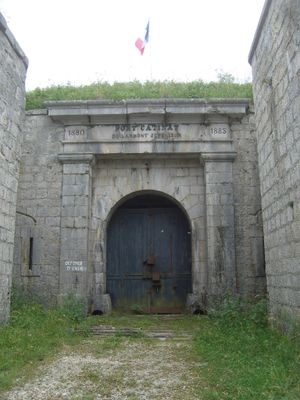
Fort Catinat du Larmont supérieur, Military fortification in Pontarlier, France.
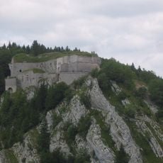
Fort Catinat du Larmont supérieur is a military fortification located on Larmont mountain at 1,170 meters altitude above Pontarlier. The structure features a defensive ditch on three sides and overlooks the Swiss border and the surrounding valleys below.
The fort was built between 1880 and 1883 as part of the Séré de Rivières defensive system along the Swiss border. It formed a linked defensive network with Fort Larmont inférieur and Fort de Joux to protect the frontier.
The fort carries the name of Marshal Nicolas de Catinat, a French military commander, reflecting its strategic importance in border defense. The site shows how France secured its boundaries with Switzerland through such structures.
Access to the fort requires a walk through mountainous terrain, so sturdy footwear and weather-appropriate clothing are advisable for this exposed location. The site sits high in the mountains where weather can change quickly and conditions may be challenging.
In June 1940, a small force of 130 soldiers defended the fort against German attacks and retained the right to keep their weapons upon surrender. This unusual surrender condition makes the fort notable in French military history.
GPS coordinates: 46.89250,6.39268
Latest update: December 14, 2025 12:23
Fort de Joux
2.6 km
Fort du Larmont inférieur
2.1 km
Église Saint-Bénigne
3 km
Porte Saint-Pierre
3.3 km
Chapelle de l'Espérance
2.8 km
Le Ball Park
4.4 km
Église de Doubs
5 km
Golf des Étraches
4.9 km
Temple
5.9 km
Théâtre Bernard Blier
3.2 km
Église Sainte-Brigide
6.5 km
Église Saint-Nicolas d'Oye-et-Pallet
6.3 km
Église Saint-Sébastien
4.3 km
Chapelle des Étraches
5.5 km
Hôpital Saint-Étienne
2.7 km
Église Saint-Pierre de La Cluse-et-Mijoux
2.4 km
Chapelle Notre-Dame-des-Côtes
5.6 km
Escalier extérieur, 2 rue Montrieux, Pontarlier
2.8 km
Église de l'Assomption d'Arçon
6.2 km
Portail devant l'église Saint-Bénigne
3 km
Chapelle Saint-Léger de La Cluse et Mijoux
2.5 km
Chapelle de l'Assomption de Monpetot
3.4 km
Immeuble, 87 rue de la République, Pontarlier
3.3 km
Immeuble, 79 rue de la République, Pontarlier
3.3 km
Immeuble, 21 rue Gambetta, Pontarlier
3.1 km
Sous-préfecture de Pontarlier
3.2 km
Chapelle Saint-Étienne de Pontarlier
2.7 km
Chapelle du Petit Saint-Claude
5.4 kmVisited this place? Tap the stars to rate it and share your experience / photos with the community! Try now! You can cancel it anytime.
Discover hidden gems everywhere you go!
From secret cafés to breathtaking viewpoints, skip the crowded tourist spots and find places that match your style. Our app makes it easy with voice search, smart filtering, route optimization, and insider tips from travelers worldwide. Download now for the complete mobile experience.
A unique approach to discovering new places❞
— Le Figaro
All the places worth exploring❞
— France Info
A tailor-made excursion in just a few clicks❞
— 20 Minutes