Meudon's forest, Public forest in western Paris suburbs, France.
Meudon's forest is a large wooded area in the western suburbs of Paris that spans multiple communes and features varied landscapes. The network includes open roads, horse trails, and marked hiking paths for different types of outdoor activities.
Meudon's forest is a remnant of the Rouvray forest, a wooded massif that once covered the western suburbs of Paris; the forests of Verrières, Versailles, Fausses-Reposes, Malmaison, Marly and Saint-Germain, plus the Bois de Boulogne, are its other fragments. Over the centuries the massif was broken up and partly turned into farmland. The Persian-language source states that the woodland was a royal hunting ground that was nationalised after the French Revolution.
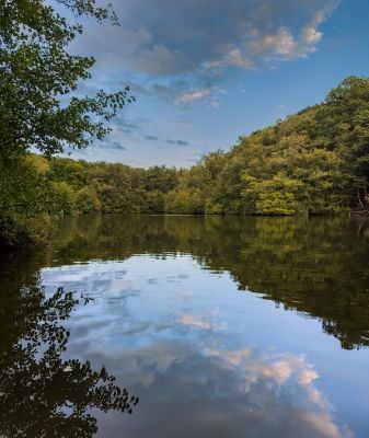
The forest's name comes from Meudon, the commune holding 520 of its 1,100 hectares. Its ponds, fed by rainwater and drainage, have shallow tails and reed beds on one side and a dam on the other; Chalais pond, once part of the château's Grande Perspective, is now reserved for the Chalais-Meudon fishing association. The GR 2 long-distance path crosses the northern part.
The pavé des Gardes, the historic route Louvois built between Paris and Versailles, crosses the massif with gradients of up to 14%. The forest has 19 km of roads open to traffic, 15 km closed, 55 km of forest tracks and 16 km of marked trails, including the GR 2. The Chalais pond is closed to the public except for members of the local fishing association.
The Meudon relay tower reaches nearly 270 m in altitude, the highest point in the Paris region after the Eiffel Tower. It is visible from Montmartre, Saint-Quentin-en-Yvelines, the Hautil forest and parts of the Chevreuse valley. Its summit, the "relais hertzien" spot, is known among mountain bikers for its bumps.
The community of curious travelers
AroundUs brings together thousands of curated places, local tips, and hidden gems, enriched daily by 92,638 contributors worldwide.