Pierres branlantes de la Davière, Natural granite boulder cluster in Sèvremoine, France
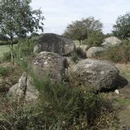
The Pierres branlantes de la Davière are a natural granite chaos: a cluster of large, rounded grey boulders with mottled white and dark patches, their weathered surfaces uneven, resting on the ground among low vegetation and partly hidden by shrubs and small trees. The name menhir de la Haute-Borne, listed on IGN maps at this spot, refers to a standing stone near the Chignardière farm that was destroyed before 1967.
The menhir de la Haute-Borne, also called menhir de Villedieu, stood near the Chignardière farm at Saint-Germain-sur-Moine, now part of Sèvremoine. Godard Faultrier gave it a height of 5 metres, while Millet de la Turtaudière, who drew it, recorded only 4 metres. Classified as a monument historique in 1889, it was destroyed at an unknown date, before 1967. The spot marked on IGN maps is the natural granite chaos of the Davière.
The name Pierres branlantes de la Davière refers to the natural granite chaos on the Davière site, which the IGN map marks where the destroyed Haute-Borne menhir once stood. The menhir itself, also called menhir de Villedieu, was near the Chignardière farm and stood 4 to 5 m tall according to early writers.
The IGN map marks the menhir's spot at the Davière granite chaos, reached by tracks from the hamlet of la Chignardière near Saint-Germain-sur-Moine. The boulders lie in low vegetation on uneven ground, so sturdy shoes help; the stones are best seen in low vegetation, not undergrowth.
The name Pierres branlantes de la Davière, used on IGN maps, marks a natural granite chaos rather than a built monument. The menhir de la Haute-Borne, also called menhir de Villedieu, once stood near the Chignardière farm; classified in 1889, it was destroyed before 1967, and its map location now points to these boulders.
The community of curious travelers
AroundUs brings together thousands of curated places, local tips, and hidden gems, enriched daily by 93,902 contributors worldwide.