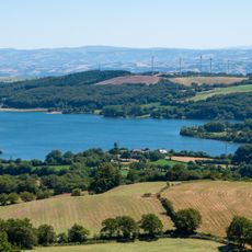
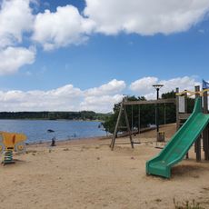
Lac de Pareloup, Reservoir in Prades-Salars, France
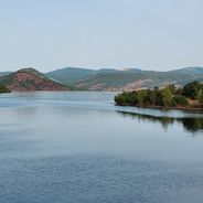
Lac de Pareloup is a reservoir in the Aveyron department that spreads over gentle hills and is lined with forested shores. Its branching arms reach into several valleys, creating sheltered coves alongside more open water surfaces that ripple in the wind.
The dam was built between 1950 and 1952 as part of a hydroelectric project on the Lévézou plateau, meant to meet energy needs after the Second World War. Its completion transformed the landscape fundamentally, turning several valleys into a connected body of water.
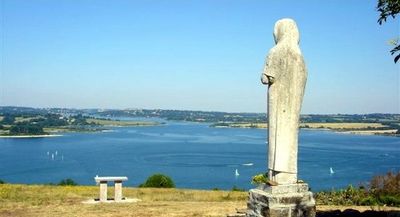
The name comes from the Pareloup region, whose rolling landscape now lies beneath the water and remains visible only along the shores. Fishing spots dot the shoreline, where locals cast lines for pike and perch while sailboats glide between the coves.
The shore road winds around much of the lake and leads to several beaches with parking areas and basic restrooms. Weekends in July and August see the beaches fill up early, so a morning visit works best.
Four rivers flow into the lake, including the Vioulou and the Alrance, forming a network of tributaries that gathers water from a wide catchment area. This system supplies drinking water to the town of Rodez and feeds a hydroelectric plant at the southern end of the dam.
Location: Canet-de-Salars
Inception: January 1, 1952
Elevation above the sea: 805 m
Address: Lac de Pareloup, France
GPS coordinates: 44.20541,2.75717
Latest update: December 5, 2025 22:29
Occitanie hosts a wide variety of lakes spread between the Pyrenees and the Massif Central. Natural lakes mainly occupy high-altitude zones in the Pyrenees, where glacial erosion has carved out cirques and basins now filled with water. Lake Oô, located at 4,950 feet (1,507 meters) altitude, receives...
Château de Salles-Curan
3.5 km
Église Saint-Georges de Camboulas
8.9 km
Pont de Saint-Georges de Camboulas
8.6 km
Église Notre-Dame d'Aures d'Arvieu
3.9 km
Église Saint-Géraud de Salles-Curan
3.5 km
Église Saint-Pierre de Canet-de-Salars
3.3 km
Grenier de Monsieur
3.5 km
Lac de Villefranche-de-Panat
12.1 km
Pop Corn Labyrinthe
7.4 km
Église Notre-Dame du Poujol
10 km
Église Saint-Pierre de Curan
7.8 km
Plage des Vernhes I
1.5 km
Église Saint-Martial de Trémouilles
9.9 km
Église Saint-Saturnin de Caplongue
11 km
Église Saint-Blaise ou de la Purification-de-Notre-Dame de Vabrette
12.7 km
Saint Peter church in Ségur
11.5 km
Église Saint-Georges d'Alrance
10.1 km
Église de l'Assomption de la Capelle Farcel
10.6 km
Church in Le Vibal
12.2 km
Église Saint-Martin de Saint-Martin des Faux
3.5 km
Église Saints-Abdon-et-Sennen de Mauriac
12.7 km
Église Saint-Amans d'Arvieu
7.9 km
Plage des Vernhes II
1.5 km
Église Saint-André de Clauzelles
8.8 km
Église Saint-Pierre-ès-Liens de Figeaguet
10.3 km
Église Saint-Martin de Pont-de-Salars
8.5 km
Église Saint-Amans de Coupiaguet
10.3 km
Chapelle Notre-Dame de Salars
8.6 kmVisited this place? Tap the stars to rate it and share your experience / photos with the community! Try now! You can cancel it anytime.
Discover hidden gems everywhere you go!
From secret cafés to breathtaking viewpoints, skip the crowded tourist spots and find places that match your style. Our app makes it easy with voice search, smart filtering, route optimization, and insider tips from travelers worldwide. Download now for the complete mobile experience.
A unique approach to discovering new places❞
— Le Figaro
All the places worth exploring❞
— France Info
A tailor-made excursion in just a few clicks❞
— 20 Minutes