Lac de Saint-André, Protected lake in Porte-de-Savoie, France.
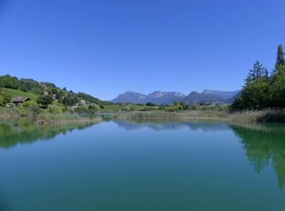
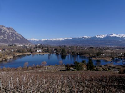
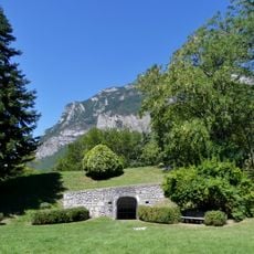
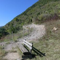
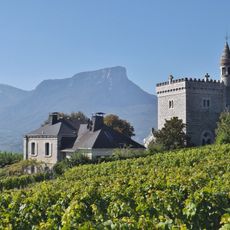
Lac de Saint-André is a lake in Porte-de-Savoie situated at the base of Mont Granier and ringed by walking trails and wooden piers. The water extends to a considerable depth, and the shoreline is divided into different zones that serve various purposes.
The water body formed from a natural event when a section of the mountain collapsed, creating a depression that gradually filled with groundwater and runoff. This geological occurrence shaped the landscape and created what exists today.
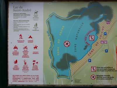
The lake serves as a protected nature site where visitors can observe diverse plant and animal life while walking along the shore and trails. The careful management of the space shows in how different areas are reserved for specific uses, reflecting the local commitment to conservation.
The lake has designated areas for swimming and fishing, with each activity following its own rules and access available throughout the year. Visitors should check beforehand which areas suit their planned activity.
The water hosts a striking diversity of dragonflies that visitors can observe with patience during warmer months. These insects are a sign of good water quality and a healthy ecosystem.
Location: Porte-de-Savoie
Elevation above the sea: 292 m
Address: Lac de Saint-André, 73800 Porte-de-Savoie, France
GPS coordinates: 45.49410,5.98628
Latest update: December 6, 2025 17:43
The Auvergne-Rhône-Alpes area has lakes from very different beginnings. Large lakes that formed from glaciers, like Lake Bourget or Lake Annecy, appeared after the glaciers in the Alps melted. They have deep water surrounded by mountains. In the Massif Central, volcanic lakes sit in old craters, such as Lake Pavin, which is nearly 7,000 years old, and Lake Issarlès, which goes down more than 100 meters deep. Some lakes are high up in the mountains, like Lake Guéry at 1250 meters, while others are in flat land or in deep valleys. There are also several artificial lakes built in the 20th century to make electricity or manage water flow. Lake Monteynard was created in 1962 on the Drac river, and Lake Saint-Étienne-Cantalès, held back by a dam on the Cère river since 1945, are popular spots for swimming, sailing, and fishing. Each lake feels different: clear and cold mountain waters, wooded shores in Jura, changing colors in volcanic craters. Visitors can walk around these places, go by boat, or just enjoy the views from the banks.
Sanctuaire Notre-Dame de Myans
2.3 km
Château de Montmélian
5.4 km
Château des Marches
1.3 km
Tours de Chignin
3.8 km
Château de Triviers
5.7 km
Casino of Challes-les-Eaux
6.1 km
Thermes of Challes-les-Eaux
6.3 km
Château de Carron
3.7 km
Chapelle de l'Annonciation de Chignin
3.2 km
Pont Morens
5.8 km
Our Lady of the fields and vines
3.7 km
Hôtel Nicolle de La Place
5.8 km
Golf des Marches
2.8 km
Église Saint-Georges du Prieuré
4.4 km
Scenic viewpoint
5.5 km
Église Saint-Pierre de Chignin
3.9 km
Église Saint-Blaise de Bellecombe
4.2 km
Église Saint-Baldoph de Saint-Baldoph
5.6 km
Belvédère du Rocher de Manettaz
6.3 km
Belvédére des Calloudes
5.8 km
Église Saint-Blaise de Francin
3.8 km
Chapelle Saint-Anthelme de Chignin
3.6 km
Église Sainte-Hélène de Sainte-Hélène-du-Lac
6.3 km
Église Saint-Maurice des Marches
1.2 km
Église Saint-Pierre d'Apremont
3.7 km
Église de l'Assomption-de-Notre-Dame de Montmélian
5.8 km
Pont Morens
5.8 km
Point de vue du Bec du Corbeau
6.2 kmReviews
Visited this place? Tap the stars to rate it and share your experience / photos with the community! Try now! You can cancel it anytime.
Discover hidden gems everywhere you go!
From secret cafés to breathtaking viewpoints, skip the crowded tourist spots and find places that match your style. Our app makes it easy with voice search, smart filtering, route optimization, and insider tips from travelers worldwide. Download now for the complete mobile experience.
A unique approach to discovering new places❞
— Le Figaro
All the places worth exploring❞
— France Info
A tailor-made excursion in just a few clicks❞
— 20 Minutes