Chest opened
+${chestReward.xp} XP
Explorer
NOUVEAU ×${chestReward.collectible.quantity}
tapez pour fermer

See the monuments around you in AR Open chests in the app

Around Us is built for your phone — point your camera at the streets and discover the monuments and places around you in augmented reality. Around Us is built for your phone — chests unlock when you walk, explore and capture nearby places.

•

Enable Location

We need your location to show you interesting places around you

Discover nearby places

Find interesting locations and hidden gems around you

Precise directions

Get accurate directions and distances to places

Your location is never shared with other users. It's only used when you tap the location button.

Mont Dardon

Log in to your account

Start exploring — it's free

Trusted by 94,521 travelers worldwide

Continue with Google
Continue with Apple
or

We will send you a code to connect

By continuing, you accept our Terms and Conditions and our Privacy Policy

Check your inbox

We've sent a pincode in your inbox. Please enter the code below.

Mont Dardon, Mountain summit in Saône-et-Loire, France

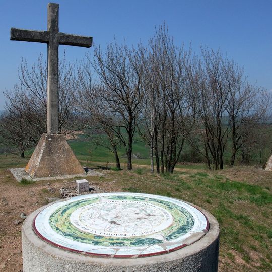
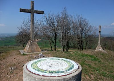
Mont Dardon is a summit in Saône-et-Loire rising to 506 metres, shared by the communes of Issy-l'Évêque, Uxeau and Sainte-Radegonde. At the top, a weathered stone cross stands on a stepped base beside a circular orientation table marked "TABLE D'ORIENTATION DU MONT DARDON" and "ALTITUDE 771 M". Two further crosses stand at the summit.

Jacques-Gabriel Bulliot identified the site in 1856, and Xavier Garenne led the first excavations in 1865. Henri Parriat revealed a Bronze Age level between 1965 and 1975, opening the way for Carole Crumley's digs from 1976, which uncovered an Iron Age centre. Excavations found two 1st-century ramparts, a chapel from the second half of the 10th century and an 11th-century square tower; the remains are not visible.

The three crosses at the summit have arms pointing toward the three parishes that share the mountain: Issy-l'Évêque, Uxeau and Sainte-Radegonde. The first crosses were set up in 1855; two were felled by violent winds in 1890 and replaced in 1892 by oak crosses from each commune. In 1935 they were rebuilt in reinforced concrete, and the inauguration drew a large crowd, recorded on a postcard.

The mountain has a parking area and picnic facilities for visitors who want to spend time outdoors in this location. Multiple hiking trails are well-marked and lead upward to the summit, with routes varying in difficulty depending on which path you take.

Since March 2017, a radio transmitter for Fusion FM 94.7 has occupied the summit, broadcasting across southern Morvan and the Charolais region. This modern addition shows how the location continues to serve as a point of connection for surrounding communities.

The community of curious travelers

AroundUs brings together thousands of curated places, local tips, and hidden gems, enriched daily by 94,521 contributors worldwide.

Start exploring
Location
Elevation above the sea
506 m
GPS coordinates
46.67707,4.03729
Latest update
October 26, 2026 01:01
Reviews
Share your experience

No review yet

Discussions
Start a discussion...

No discussion yet

« Mont Dardon - Mountain summit in Saône-et-Loire, France » is provided by Around Us (aroundus.com). Images and texts are derived from Wikimedia project under a Creative Commons license. You are allowed to copy, distribute, and modify copies of this page, under the conditions set by the license, as long as this note is clearly visible.

Discover hidden gems everywhere you go!

From secret cafés to breathtaking viewpoints, skip the crowded tourist spots and find places that match your style. Our app makes it easy with voice search, smart filtering, route optimization, and insider tips from travelers worldwide. Download now for the complete mobile experience.
Around Us App Screenshot
❝

A unique approach to discovering new places❞

— Le Figaro

❝

All the places worth exploring❞

— France Info

❝

A tailor-made excursion in just a few clicks❞

— 20 Minutes

Around Us
Travel Guide & Maps
Download

Send to your phone

QR Code
1

Open the camera app on your mobile.

2

Point at the QR code with your camera. A notification will appear.

3

Tap the notification to open the link.