Mont Serein, Mountain summit in Vaucluse, France
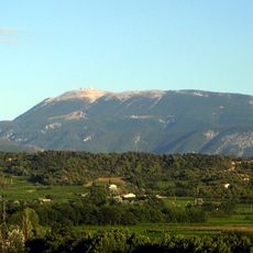
Mont Serein is a secondary summit of 1437 m on the northern side of Mont Ventoux, in the commune of Beaumont-du-Ventoux. Its slopes are limestone, with exposed grey and white rock, scattered trees and dry grass. A long low building with a grey roof stands near the base, and a black-and-yellow striped pole marks the lower slope.
Development as a recreational site began in the late 1920s through the efforts of writer and alpinist Pierre de Champeville. His initiative laid the foundation for the location's current use as a leisure destination.
Mont Serein takes its name from the Latin for "calm mountain", a reference to its sheltered position below the Ventoux summit. The winter sports station on its slopes grew from a chance event: a lost ski that slid from the summit down the Fontfiole ravine to the plateau, after which the site was rediscovered. Until then the plateau had been used only by shepherds for summer grazing.
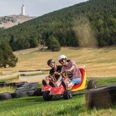
Mont Serein is reached by the D974 road from Malaucène, which continues to the Ventoux summit; a bus links Carpentras and Mont Serein via Malaucène. The ski area sits between 1400 and 1800 metres, with 12 km of alpine pistes served by 9 téléskis, 7 km of cross-country trails and 8 km of snowshoe routes. In July and August, dévalkart descents run on the piste de la Lisière in the afternoon.
The summit's name means "serene" in French, yet it was a lost skier who put it on the map: in the early 1930s a skier sliding from the Ventoux summit down the Fontfiole ravine ended up on this plateau, until then used only by shepherds for summer pasture. A secondary road via Mont Serein linking Malaucène to the Ventoux summit opened at that time.
The community of curious travelers
AroundUs brings together thousands of curated places, local tips, and hidden gems, enriched daily by 94,111 contributors worldwide.