Mont des Avaloirs, Mountain summit in Mayenne, France
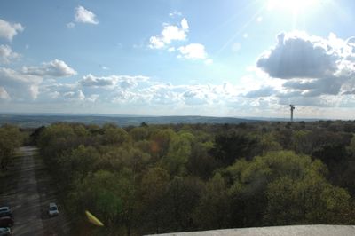
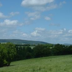
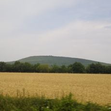
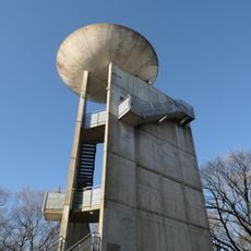
Mont des Avaloirs is a mountain summit in the Alpes Mancelles region standing at 416 meters tall with an 18.5-meter observation tower. The platform at the top provides sweeping views of the surrounding countryside on clear days.
The mountain became part of the Normandie-Maine Regional Natural Park established to protect natural areas across four departments. This designation safeguarded the region's habitats and landscape for future generations.
Street artist Seb Toussaint painted a nature-themed mural on the observation tower featuring local plants and animals. The artwork shifts in appearance depending on the time of day, adding a creative touch to the summit experience.
To reach the observation platform, visitors need to climb 108 stairs in the tower. The site is generally accessible, though the stairs can be narrow and it is wise to be cautious during windy weather.
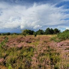
At the base of the summit lies a peat bog home to carnivorous plants and rare animal species including the Fire Salamander. This protected ecosystem makes the site a refuge for specialized creatures rarely found elsewhere.
Location: Mayenne
Elevation above the sea: 416 m
Website: http://geodesie.ign.fr/fiches/index.php?module=e&action=fichepdf&source=carte&sit_no=5318501
GPS coordinates: 48.45063,-0.14439
Latest update: December 6, 2025 16:03
Mayenne's historical sites include medieval castles, fortresses, religious buildings, and museums. The natural areas consist of Mont des Avaloirs, the prehistoric caves of Saulges, public gardens, and parks. Visitors can explore military and civil architecture from the 9th to the 18th century, art collections, archaeological sites, and natural landscapes typical of the region.
Normandie-Maine Regional Natural Park
7.2 km
Butte Chaumont
9.3 km
Belvédère du mont des Avaloirs
20 m
Réserve naturelle régionale Mont des Avaloirs
1.7 km
Église Saint-Julien de Saint-Julien-des-Églantiers
5.4 km
Église Saint-Pierre-et-Saint-Paul de La Roche-Mabile
8.1 km
Pierre au Diable de Saint-Pierre-des-Nids
6.8 km
Église Saint-Pierre de Saint-Pierre-des-Nids
6.6 km
Manoir de Ravigny
6 km
Église Saint-Julien de Ravigny
6 km
Église Saint-Cyr-et-Sainte-Julitte de Saint-Cyr-en-Pail
7.5 km
Église Saint-Martin de Champfrémont
4.6 km
Église Sainte-Thérèse de Pré-en-Pail
4.1 km
Église Sainte-Marie de Boulay-les-Ifs
3.4 km
Chapelle Sainte-Anne de Champfrémont
3.9 km
Église Saint-Calais de Saint-Calais-du-Désert
9.4 km
Église Saint-Samson de Saint-Samson
4.9 km
Chapelle Notre-Dame-du-Bon-Secours de Saint-Cyr-en-Pail
7.7 km
Église Saint-Pierre de Gesvres
9.1 km
Chapelle du bourg de Gesvres
9.1 km
Église Notre-Dame de La Ferrière-Bochard
9.3 km
Église de Saint-Denis-sur-Sarthon
7 km
Église Notre-Dame de Gandelain
5.3 km
Église Saint-Pierre de Ciral
4.9 km
If séculaire de Lalacelle
2.7 km
Église Saint-Pierre de Longuenoë
9.3 km
Église Saint-Ellier de Saint-Ellier-les-Bois
8.5 km
Église Saint-Martin de Lalacelle
2.7 kmVisited this place? Tap the stars to rate it and share your experience / photos with the community! Try now! You can cancel it anytime.
Discover hidden gems everywhere you go!
From secret cafés to breathtaking viewpoints, skip the crowded tourist spots and find places that match your style. Our app makes it easy with voice search, smart filtering, route optimization, and insider tips from travelers worldwide. Download now for the complete mobile experience.
A unique approach to discovering new places❞
— Le Figaro
All the places worth exploring❞
— France Info
A tailor-made excursion in just a few clicks❞
— 20 Minutes