Enable Location

We need your location to show you interesting places around you

Discover nearby places

Find interesting locations and hidden gems around you

Precise directions

Get accurate directions and distances to places

Your location is never shared with other users. It's only used when you tap the location button.

Ouvrage Laudrefang

Log in to your account

Start exploring — it's free

Trusted by 62,379 travelers worldwide

Continue with Google
Continue with Apple
or

We will send you a code to connect

By continuing, you accept our Terms and Conditions and our Privacy Policy

Check your inbox

We've sent a pincode in your inbox. Please enter the code below.

Ouvrage Laudrefang

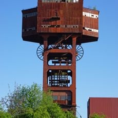
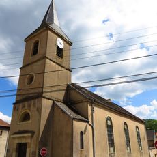
Ouvrage Laudrefang, Military fortification in Moselle, France

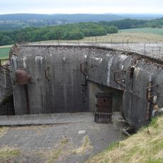
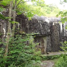
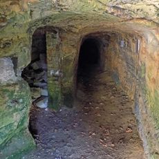
Ouvrage Laudrefang is an underground military fortification in Moselle with five combat blocks connected by galleries that extend across multiple levels approximately 30 meters (100 feet) deep. The complex houses barracks, ammunition storage, a power plant, kitchen, and medical facilities designed to support extended occupation by troops.

The fortification was built in 1931 as part of the Maginot Line to defend the French border. In June 1940 it endured heavy German artillery bombardment before the French surrender ended the combat.

The structure represents French military engineering of the 1930s, demonstrating the national focus on territorial defense through permanent fortifications.

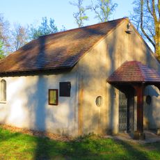
Access is through an opening at the top of the hill that leads down into the underground chambers. Visitors should be ready for narrow spaces and changing light levels, as interior areas are only partially lit.

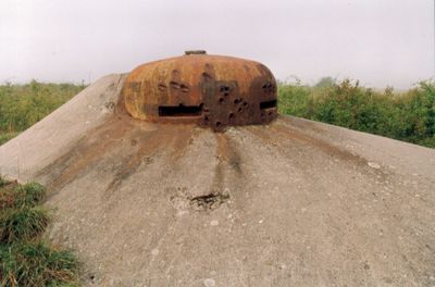
Block 3 stands apart from the others and was equipped with twin machine guns and mortar embrasures, making it a critical defensive position. This isolated location allowed defenders to engage attackers from multiple angles.

The community of curious travelers

AroundUs brings together thousands of curated places, local tips, and hidden gems, enriched daily by 60,000 contributors worldwide.

Start exploring
GPS coordinates
49.08936,6.64803
Latest update
December 14, 2025 18:08
Around this place
Basilique Notre-Dame-de-Bon-Secours de Saint-Avold
France

Basilique Notre-Dame-de-Bon-Secours de Saint-Avold

4.4 km
Ouvrage Bambesch
France

Ouvrage Bambesch

4.2 km
Ouvrage Einseling
France

Ouvrage Einseling

2.1 km
Abbaye Saint-Martin-des-Glandières
France

Abbaye Saint-Martin-des-Glandières

3.1 km
Ouvrage Téting
France

Ouvrage Téting

2.2 km
Puits I
France

Puits I

2 km
Chapelle de Pontpierre
France

Chapelle de Pontpierre

2.6 km
Mine de plomb du Bleiberg
France

Mine de plomb du Bleiberg

4.3 km
Golf de Faulquemont
France

Golf de Faulquemont

3.6 km
Église Saint Félix de Nole, Bambiderstroff
France

Église Saint Félix de Nole, Bambiderstroff

4.2 km
Église Saint-Magne de Longeville-lès-Saint-Avold
France

Église Saint-Magne de Longeville-lès-Saint-Avold

3.8 km
Église Saint-Gengoulf de Valmont
France

Église Saint-Gengoulf de Valmont

3.7 km
Église Saint-Denis de Teting-sur-Nied
France

Église Saint-Denis de Teting-sur-Nied

3.7 km
Église Notre-Dame-de-la-Nativité de Folschviller
France

Église Notre-Dame-de-la-Nativité de Folschviller

3.6 km
Église Saint-Martin de Tritteling
France

Église Saint-Martin de Tritteling

2.3 km
Église orthodoxe serbe Saint-Prince-Lazare de Valmont
France

Église orthodoxe serbe Saint-Prince-Lazare de Valmont

3.5 km
Église Saint-Jean-Bosco du Cité-Furst
France

Église Saint-Jean-Bosco du Cité-Furst

2.8 km
Église de la Nativité-la-Bienheureuse-Vierge-Marie de Laudrefang
France

Église de la Nativité-la-Bienheureuse-Vierge-Marie de Laudrefang

942 m
Église Sainte-Anne de Redlach
France

Église Sainte-Anne de Redlach

3.4 km
Chapelle Saint-Sébastien de Dourd'hal
France

Chapelle Saint-Sébastien de Dourd'hal

1.8 km
Chapelle de la Trinité de Teting-sur-Nied
France

Chapelle de la Trinité de Teting-sur-Nied

4.5 km
Église Saint-Thomas de Dourd'hal
France

Église Saint-Thomas de Dourd'hal

1.3 km
Chapelle Saint-Antoine de Bambiderstroff
France

Chapelle Saint-Antoine de Bambiderstroff

3.9 km
Chapelle Notre-Dame-de-la-Paix de Bambiderstroff
France

Chapelle Notre-Dame-de-la-Paix de Bambiderstroff

4 km
Chapelle du cimetière de Longeville-lès-Saint-Avold
France

Chapelle du cimetière de Longeville-lès-Saint-Avold

3.3 km
Chapelle Notre-Dame-de-Bon-Secours de Kleindal
France

Chapelle Notre-Dame-de-Bon-Secours de Kleindal

4.2 km
Chapelle de l'abbaye bénédictine Saint-Martin-de-Glandière de Longeville-lès-Saint-Avold
France

Chapelle de l'abbaye bénédictine Saint-Martin-de-Glandière de Longeville-lès-Saint-Avold

3.2 km
Chapelle des Quatorze-Saints-Auxiliaires de Folschviller
France

Chapelle des Quatorze-Saints-Auxiliaires de Folschviller

3.6 km
Show the full map
« Ouvrage Laudrefang - Military fortification in Moselle, France » is provided by Around Us (aroundus.com). Images and texts are derived from Wikimedia project under a Creative Commons license. You are allowed to copy, distribute, and modify copies of this page, under the conditions set by the license, as long as this note is clearly visible.

Discover hidden gems everywhere you go!

From secret cafés to breathtaking viewpoints, skip the crowded tourist spots and find places that match your style. Our app makes it easy with voice search, smart filtering, route optimization, and insider tips from travelers worldwide. Download now for the complete mobile experience.

Around Us App Screenshot

A unique approach to discovering new places

Le Figaro

All the places worth exploring

France Info

A tailor-made excursion in just a few clicks

20 Minutes

Around Us
Travel Guide & Maps
Download

Send to your phone

QR Code
1

Open the camera app on your mobile.

2

Point at the QR code with your camera. A notification will appear.

3

Tap the notification to open the link.