Chest opened
+${chestReward.xp} XP
Explorer
NOUVEAU ×${chestReward.collectible.quantity}
tapez pour fermer

See the monuments around you in AR Open chests in the app

Around Us is built for your phone — point your camera at the streets and discover the monuments and places around you in augmented reality. Around Us is built for your phone — chests unlock when you walk, explore and capture nearby places.

•

Enable Location

We need your location to show you interesting places around you

Discover nearby places

Find interesting locations and hidden gems around you

Precise directions

Get accurate directions and distances to places

Your location is never shared with other users. It's only used when you tap the location button.

Pointe du Toulinguet

Log in to your account

Start exploring — it's free

Trusted by 92,804 travelers worldwide

Continue with Google
Continue with Apple
or

We will send you a code to connect

By continuing, you accept our Terms and Conditions and our Privacy Policy

Check your inbox

We've sent a pincode in your inbox. Please enter the code below.

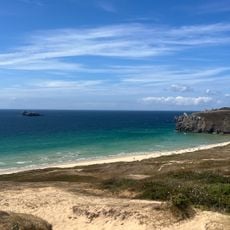
Pointe du Toulinguet, Rocky cape and military fortification in Camaret-sur-Mer, France.

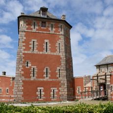
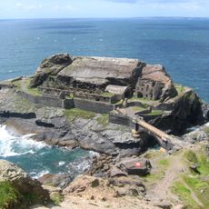
Pointe du Toulinguet is a rocky cape at the western end of the Crozon peninsula in Camaret-sur-Mer. Its cliffs are made of pale grey-beige quartzite sandstone of the Armorican sandstone formation, with deep vertical fissures and dark recesses at the waterline. On the scrub-covered summit stand an 1848 lighthouse, a model-tower no. 3 with its enclosing wall, and a 1949 signal station.

The cape's defences include a prehistoric fortified site and a lower battery attributed to Vauban, of which only a platform remains hard to make out. A model-tower no. 3 with its surrounding wall dates from 1812, and four batteries were added in 1883 and 1899. The site lies on the military ground of the Toulinguet signal station, built in 1949, and its lighthouse dates from 1848.

The name Toulinguet comes from the Breton Toul inged, "hole of the plover", referring to a pierced rock offshore. The cape's other Breton name is Beg ar Garreg Hir. The site lies within the Navy signal station grounds and is closed to visitors, so the toponymy is what remains accessible.

The site lies on the Marine nationale grounds of the Toulinguet semaphore and is closed to the public, so it cannot be visited, guided or otherwise. Views of the cape, its 1848 lighthouse and the white towers are had from the coastal path around Camaret-sur-Mer and from the sea.

The cape's Breton name, Toul inged, means "hole of the plover", referring to a pierced rock offshore. On 8 August 1918 the British cargo ship Swansea-Vale, of 1,310 tons, struck the Trépied rocks west of the point and sank midway between it and Fort de Bertheaume; the crew had time to evacuate.

The community of curious travelers

AroundUs brings together thousands of curated places, local tips, and hidden gems, enriched daily by 92,804 contributors worldwide.

Start exploring
Location
GPS coordinates
48.28012,-4.62689
Latest update
October 26, 2026 04:43
Reviews
Share your experience

No review yet

Discussions
Start a discussion...

No discussion yet

« Pointe du Toulinguet - Rocky cape and military fortification in Camaret-sur-Mer, France » is provided by Around Us (aroundus.com). Images and texts are derived from Wikimedia project under a Creative Commons license. You are allowed to copy, distribute, and modify copies of this page, under the conditions set by the license, as long as this note is clearly visible.

Discover hidden gems everywhere you go!

From secret cafés to breathtaking viewpoints, skip the crowded tourist spots and find places that match your style. Our app makes it easy with voice search, smart filtering, route optimization, and insider tips from travelers worldwide. Download now for the complete mobile experience.

Around Us App Screenshot
❝

A unique approach to discovering new places❞

— Le Figaro

❝

All the places worth exploring❞

— France Info

❝

A tailor-made excursion in just a few clicks❞

— 20 Minutes

Around Us
Travel Guide & Maps
Download

Send to your phone

QR Code
1

Open the camera app on your mobile.

2

Point at the QR code with your camera. A notification will appear.

3

Tap the notification to open the link.