Pont de l'Iroise

Log in to your account

AroundUs is a community-driven map of interesting places, built by curious explorers like you. It grows with every review, story, and photo you share.
Connect to save your favorite spots, contribute locations, and create personalized routes.
By continuing, you accept our Terms and Conditions and our Privacy Policy

Pont de l'Iroise

Add to collection
Map
Suggest a change
Share

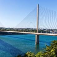
Pont de l'Iroise, Cable-stayed bridge in Finistère, France

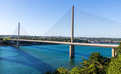
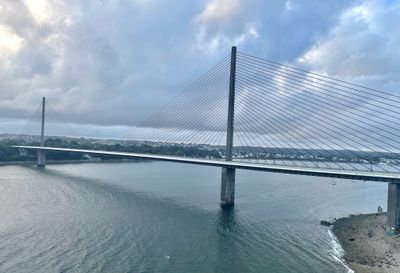
The Pont de l'Iroise is a cable-stayed bridge made of reinforced concrete that stretches 800 meters across the Elorn River, connecting Le Relecq-Kerhuon and Plougastel-Daoulas. The two towers rise approximately 113 meters and support the roadway using steel cables strung between them.

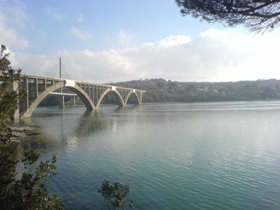
Construction finished in 1994 to provide a modern crossing and replace the older Albert-Louppe Bridge that had served the area for decades. The project was part of regional improvements to connect settlements with centers further south and reduce traffic congestion.

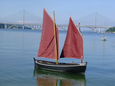
The bridge takes its name from the Iroise waters and connects two communities that were previously separated by significant detours. It has become woven into the daily routines of residents traveling between home and work in the nearby urban areas.

The bridge carries heavy traffic during rush hours, especially in the morning and evening when commuters travel between the communities. Plan to cross flexibly to avoid peak times if you have time to spare.

The bridge's main span stretches 400 meters without intermediate support, making it one of the longest unsupported spans for cable-stayed bridges in France. This remarkable span allowed engineers to cross the river without major disruption to river traffic.

Location: Le Relecq-Kerhuon

Location: Plougastel-Daoulas

Inception: 1994

Architects: Michel Placidi

Official opening: July 12, 1994

Height: 113 m

Length: 800.05 m

Longest Span: 400 m

Made from material: reinforced concrete

Address: Pont de l'Iroise, 29470 Le Relecq-Kerhuon, France

Phone: +33298465332

Website: https://brest.fr

GPS coordinates: 48.38750,-4.39778

Latest update: December 11, 2025 19:22

Photos
Discover the tourist sites of Brest

Brest is a port city in Brittany with deep roots in seafaring and military history. After World War II, the city rebuilt itself and now combines modern architecture with preserved landmarks like Tanguy Tower and Saint-Malo Street. Visitors can explore Océanopolis, an ocean discovery center, tour the...

Reviews

Visited this place? Tap the stars to rate it and share your experience / photos with the community! Try now! You can cancel it anytime.

« Pont de l'Iroise - Cable-stayed bridge in Finistère, France » is provided by Around Us (aroundus.com). Images and texts are derived from Wikimedia project under a Creative Commons license. You are allowed to copy, distribute, and modify copies of this page, under the conditions set by the license, as long as this note is clearly visible.

Discover hidden gems everywhere you go!

From secret cafés to breathtaking viewpoints, skip the crowded tourist spots and find places that match your style. Our app makes it easy with voice search, smart filtering, route optimization, and insider tips from travelers worldwide. Download now for the complete mobile experience.

Around Us App Screenshot

A unique approach to discovering new places

Le Figaro

All the places worth exploring

France Info

A tailor-made excursion in just a few clicks

20 Minutes