Enable Location

We need your location to show you interesting places around you

Discover nearby places

Find interesting locations and hidden gems around you

Precise directions

Get accurate directions and distances to places

Your location is never shared with other users. It's only used when you tap the location button.

Redoute du Moulin de Saquet

Log in to your account

Start exploring — it's free

Trusted by 62,063 travelers worldwide

Continue with Google
Continue with Apple
or

We will send you a code to connect

By continuing, you accept our Terms and Conditions and our Privacy Policy

Check your inbox

We've sent a pincode in your inbox. Please enter the code below.

Redoute du Moulin de Saquet

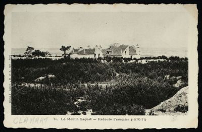
Redoute du Moulin de Saquet, 19th century fortification in Vitry-sur-Seine, France

The Redoute du Moulin de Saquet is a 19th century earthwork fortification located between Fort d'Ivry and the Hautes-Bruyères redoubt on the southern edge of Paris. It formed part of a four-fort defense network across Vitry-sur-Seine territory that controlled access to the Seine River and the approaches toward Villejuif.

The fortification was hastily built in 1870 during the Franco-Prussian War to reinforce Paris' southern defenses against advancing German forces. During the Paris Commune that followed, it became a site of intense fighting as communards held it as a strategic position until their defeat in May 1871.

The fortification takes its name from a former windmill demolished in 1857, and this heritage lives on through local street names like Avenue du Moulin-de-Saquet. The naming reflects how the site's past remains woven into the urban fabric of the area today.

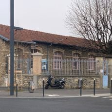
The ruins sit in a residential area south of Paris and are surrounded by paths and green spaces that allow visitors to explore the surviving structures. You can wander through independently, though you should expect uneven ground and areas covered by vegetation.

The redoubt was one of the last positions defended by Paris Commune fighters during their final collapse in May 1871, making it a rare place where visitors can see the built traces of that brief but intense uprising. The earthen walls still bear the marks of sustained combat from that period.

The community of curious travelers

AroundUs brings together thousands of curated places, local tips, and hidden gems, enriched daily by 60,000 contributors worldwide.

Start exploring
Location
GPS coordinates
48.78960,2.37653
Latest update
December 14, 2025 17:43
« Redoute du Moulin de Saquet - 19th century fortification in Vitry-sur-Seine, France » is provided by Around Us (aroundus.com). Images and texts are derived from Wikimedia project under a Creative Commons license. You are allowed to copy, distribute, and modify copies of this page, under the conditions set by the license, as long as this note is clearly visible.

Discover hidden gems everywhere you go!

From secret cafés to breathtaking viewpoints, skip the crowded tourist spots and find places that match your style. Our app makes it easy with voice search, smart filtering, route optimization, and insider tips from travelers worldwide. Download now for the complete mobile experience.

Around Us App Screenshot

A unique approach to discovering new places

Le Figaro

All the places worth exploring

France Info

A tailor-made excursion in just a few clicks

20 Minutes

Around Us
Travel Guide & Maps
Download

Send to your phone

QR Code
1

Open the camera app on your mobile.

2

Point at the QR code with your camera. A notification will appear.

3

Tap the notification to open the link.