Île de la Serre, River island in Porcieu-Amblagnieu and Villebois, France
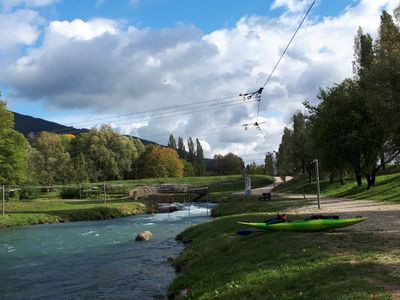
Île de la Serre is a river island situated between the Ain and Isère rivers in the Rhône-Alpes region, featuring a 600-meter whitewater course designed for paddling sports. The course incorporates multiple technical sections that test river skills at different levels of difficulty.
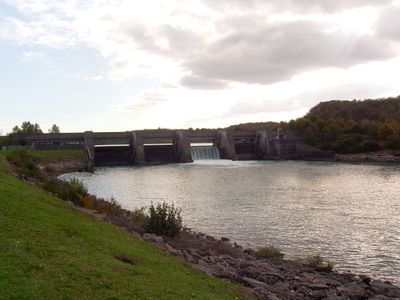
The island formed gradually over centuries through natural river processes that shaped the land between the two waterways. In recent decades, the area was developed into a dedicated water sports facility to harness its natural characteristics.
The island hosts numerous water sport activities throughout the year, connecting local communities through shared outdoor recreational experiences and river-based traditions.
The site is accessible throughout the year, with peak activity during warmer months when water flow and temperature conditions are most favorable. Waterproof footwear and splash protection are recommended since you will be close to moving water and splashing.
The whitewater course uses a system of 80 adjustable gates that can modify the difficulty of each run and create different route options. This gate system allows operators to tailor the experience from beginner-friendly to expert level and change it based on water conditions.
Location: Porcieu-Amblagnieu
Location: Villebois
GPS coordinates: 45.85080,5.41167
Latest update: December 21, 2025 16:05
Grottes de La Balme
5.6 km
Château du Vernay
5.4 km
Fresco of Saint Christopher of Saint-Sorlin-en-Bugey
4.8 km
Pont de Sault-Brénaz
479 m
Église Sainte-Marie-Madeleine de Saint-Sorlin-en-Bugey
4.6 km
Fontaine-lavoir de Collonges
5.3 km
Église Saint-Martin de Villebois
1.8 km
Église Saint-Cyr de Souclin
2.9 km
Église de l'Annonciation de Sault
721 m
Église Saint-Laurent de Vertrieu
4.2 km
Villebois monolith
1.8 km
Town hall of Saint-Sorlin-en-Bugey
4.9 km
Town hall of Souclin
2.9 km
Chapelle Saint-Christophe de Brénaz
1.6 km
Maison de la pierre et du ciment
3.9 km
War memorial of Saint-Sorlin-en-Bugey
4.9 km
War memorial of Souclin
2.9 km
War memorial of Sault-Brénaz
833 m
Chapelle du cimetière de Sault
821 m
War memorial of Villebois
1.8 km
Château vieux de Vertrieu
4 km
Town hall of Villebois
1.8 km
Château de Saint-Sorlin-en-Bugey
4.6 km
Cemetery cross of Serrières-de-Briord
5.4 km
Town hall of Sault-Brénaz
816 m
Château Neuf de Vertrieu
4.2 km
Cemetery cross of Brénaz
1.6 km
Cemetery cross of Sault
803 mVisited this place? Tap the stars to rate it and share your experience / photos with the community! Try now! You can cancel it anytime.
Discover hidden gems everywhere you go!
From secret cafés to breathtaking viewpoints, skip the crowded tourist spots and find places that match your style. Our app makes it easy with voice search, smart filtering, route optimization, and insider tips from travelers worldwide. Download now for the complete mobile experience.
A unique approach to discovering new places❞
— Le Figaro
All the places worth exploring❞
— France Info
A tailor-made excursion in just a few clicks❞
— 20 Minutes